Entry #20: Mile 49, Providence, Rhode Island. Heading for Providence

I begin the Rhode Island section of my journey by discovering some interesting facts about the Ocean State. The first thing I discovered upon my arrival in Pawtucket is that all of Pawtucket east of the Blackstone River was part of Massachusetts until 1862. The second thing I discovered is that, once again the Post Road splits into two roads, one heads south along the eastern shore of Narragansett Bay to Newport and the other passes through Providence by one of two roads, both of which require a ferry crossing, then heads south along the western shore of Narragansett Bay. The land traveler from Newport to New York was required to take a trip by boat across Narragansett Bay to the western shore, where the two roads met in what is now South Kingstown, Rhode Island. From here the road traveled in a westerly direction to Westerly, Rhode Island and continued along the Connecticut coast, reaching lower Manhattan after roughly another 150 miles. There is still a lot of walking to do.
The most surprising fact to me is that Providence, Rhode Island was not a very large or particularly important town in the colonial era. Newport was the dominant town in this area of the country and maintained its primacy until the Revolutionary War, after which it fell into a long and slow decline while Providence took advantage of the fruits of the Industrial Revolution to become the second largest city in New England after Boston. This explains why the main road is often called the road to Bristol or the path to Newport. Sarah Kemble Knight must have passed through what is now Providence in 1704, but it did not merit a mention. Alexander Hamilton “went by Providence” on his way home and stated that Providence was “a small but long town situated close upon the water upon rocky ground, much like Marblehead but not a sixth part so large.”(1) Marblehead, in Massachusetts, although once a very important seaport, currently has a population of 20,377 (2000 US Census), while the city of Providence alone has a population of 171,000, and the Metropolitan Statistical Area (MSA) of the same name contains 1.6 million people in Rhode Island and Southeastern Massachusetts, the 36th largest MSA in the United States as of 2008 (US Census Bureau). James Birket completely bypassed Providence in 1750 and headed straight for Newport down the east side of Narragansett Bay. In truth, he too must have passed through at least a portion of what is now East Providence as we shall see, but he made no special effort to visit what is now the capital of Rhode Island. The importance of Providence rose with the arrival of turnpikes, canals, railroads, highways, and factories. The dirt trails of the seventeenth and eighteenth century bypassed the area or passed through a tranquil and lightly populated area on the way to the bright lights of the “News”: Newport, New London, New Haven, and New York.
*****
But first, back to Pawtucket. As I stated above, the east side of Pawtucket belonged to Massachusetts until 1862. I am astounded that states in New England were still haggling over borders as late as the Civil War. All the territory east of the Blackstone River originally was part of Rehoboth in the Plymouth Colony and the part of Massachusetts. The waterfalls here provide a formidable obstacle to cross, and the fact that a bridge was not constructed until 1713 to cross the falls indicates that this was not the main-travelled road. A glance at a map of Rhode Island clearly indicates that the most direct way to Newport is via Bristol directly south of Pawtucket. On the other hand, if Newport is not your destination, but rather New Haven as in the case of Sarah Knight, the most direct route would be to cross over to the western shore of Narragansett Bay, which required passage through Providence and crossing the Blackstone River. By 1744 the easiest way was to follow Hamilton over the wooden bridge at what he mistakenly called “Nantucket Falls,” the noise of which “so scared my horses that I was obliged to light and lead them over the bridge.”(2) Hamilton continued his journey to Newport by crossing back over the river, this time at what is today India Point, but was known as “Providence Ferry” or “Lower Ferry” to distinguish it from a third crossing slightly north of the lower ferry but south of Pawtucket Falls. Both of these ferries led the traveler into Rehoboth, in the colony of Massachusetts, although today they cross the Seekonk River (the name of the Blackstone River below Pawtucket Falls) into East Providence, Rhode Island.

Birket in 1750 followed the road south from Pawtucket to Rehoboth, Swansea, and Bristol, Rhode Island. The area around Pawtucket at the time was known as Seekonk Plain and was described by Birket as being “about 3 miles over without a shrub and quite Levell, surrounded with woods [it] makes no disagreeable appearance.”(3) Even today the absence of any undulation on the road into Pawtucket center is noticeable, although the scenery is not as
Pawtucket, 1827. Map by Edmund Walcott. Note that Pawtucket at this time comprised only what is now East Pawtucket and was a part of Massachusetts. Pawtucket broke away from Seekonk, MA to become a separate town at this time and, together with the area west of the Pawtucket River (then North Providence), became Pawtucket, Rhode Island in 1862. The curving road from North to South is the oldest road to Rehoboth, Bristol, and Newport, while the straighter road to the east that heads due south is the Newport Turnpike. Note the loop just to the east of Pawtucket Bridge. Originally the traveller looped around on Main Street to reach Pawtucket Bridge but a shorter road appeared later running over the hill. Also note the ubiquitous “Plains,” a fact noted by Birket in 1750. Map reproduced from Bowen’s Early Rehoboth, 1950.
agreeable in appearance as it was to Birket. Cottage Street is a straight road which, upon entering from Massachusetts, is at first lined with slightly run-down stores, which change into slightly run-down houses a few blocks after crossing the Massachusetts line. These in turn are followed by very run-down industrial buildings, many which are abandoned. After a mile I pass a cemetery on the left-hand side. North Bend Street “bends” in a southerly direction at this point around the western edge of the cemetery. A map of the old roads of what is now Pawtucket show Cottage Street as the Road to Attleborough, while South Bend Street, a continuation of North Bend after Walcott Street, becomes the Road to Rehoboth. One half mile after turning onto North Bend Street from Cottage, I turn right onto Walcott Street which heads west towards the Falls and, as the colonial traveler would have done, turn right onto the curved Main Street from Walcott to travel the last 400 yards to the Bridge at Pawtucket Falls, a redundant phrase as Pawtucket means waterfall place in Algonkian.
*****
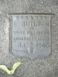
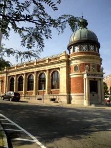
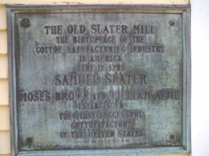
Clockwise from top left: 1. Plaque in sidewalk, Pawtucket RI. Proof that government works. 2. milestone indicating two miles to Providence Court House. Date unknown, North Main Street, Providence, RI at Pawtucket line. 3. Pawtucket Library, formerly old Post Office. They don’t make them like they used to. 4. Plaque on Slater Mill indicating the importance of this site in American History. Maybe not the Battle of Gettysburg, but probably as important in its own way.
In addition to frightening Hamilton’s horse, the falls at Pawtucket have a special place in the history of the early American Republic. Slater Mill, built in 1790 and visible from the bridge, was the first successful textile factory in the United States and is considered the birthplace of the Industrial Revolution in America. The importance of mills and factories in early America cannot be underestimated. The rise of industrial mill towns and factory towns in the northeast Untied States in the first half of the nineteenth century was directly responsible for the massive increase in immigration and the dramatic rise in wealth that created what is now the largest economy in the world by a wide margin (US GDP in 2010 according to The Economist Intelligence Unit is $14.8 trillion, a quarter of the entire world GDP, while the the next three largest economies of China, Japan, and Germany combined do not quite equal that of the United States). The location here at Pawtucket Falls was chosen to take advantage of the force of falling water to power machinery to spin cotton fabric. The success here at Pawtucket initiated a flood of mill construction along rivers all around New England, including those located at Lowell, Lawrence, and Manchester New Hampshire and the success of these mills resulted in the rapid growth of the principal ports which handled the shipment of much of the production of the mills, Boston and Providence.
Pawtucket today is similar to many of the older mill towns of New England. The old mill buildings are quite striking, even bucolic, sitting alongside the river, where bank swallows glide above the falls hunting for insects. However, the downtown area contains quite a few vacant buildings, and there are few people out and about on Main Street. The older institutional buildings, such as the library, are quite elegant, but there is definitely a lack of commercial activity, which makes the area surrounding the Slater Mill park area seem forlorn. It troubles me that so many small cities such as this one struggle to survive despite the surfeit of grand old buildings and potential commercial and residential space. The question of how to reenergize the small mill towns of America, to increase population density and create a critical mass of people engaged and interested in revitalizing the endangered downtown areas should be one of the major priorities of government at all levels, as this will undoubtedly help to solve one of the biggest problems we face in this country, the dependence we have upon cars and the oil required to power them.
I eat in one of the few restaurants, a diner on Main Street, and begin my walk to Providence. I leave Pawtucket Center and follow East Street to George Street and then to Pawtucket Avenue, which becomes North Main Street in Providence after one and a half miles. This was originally called the Pawtucket trail and in 1807 became the Pawtucket Turnpike, which might explain why it is so straight (4). Immediately upon entering Providence I encounter a milestone in the center of the road indicating two miles to the Court House in Providence. North Main and Pawtucket Avenue are part of US Route 1, although this section is not as built up as some parts I have encountered previously. The road is relatively straight and gradually descends from the plain that I have been walking along most of the day. After two miles of walking through intermittent residential and commercial neighborhoods, my stroll in the hot sun ends as I arrive at a shady park adjacent to the newly renovated Providence River. The park is part of the Roger Williams National Memorial, which commemorates the life of Roger Williams, founder of the state of Rhode Island and champion of religious freedom. Ranger John McNiff explains the mission of the park to me with enthusiasm and is a great source of information about Rhode Island, and exemplifies what makes the National Park Service the most treasured of government services. He shows me a map of Rhode Island with place names that existed before the arrival of Europeans settlers and also helps me to understand the geography and layout of early Providence. Although not the most important of early colonial towns, Providence is sufficiently interesting to merit a separate entry of its own. I will end here and resume my next entry with a deeper description of Providence, after which I will follow the old roads through Rhode Island and on to Connecticut.
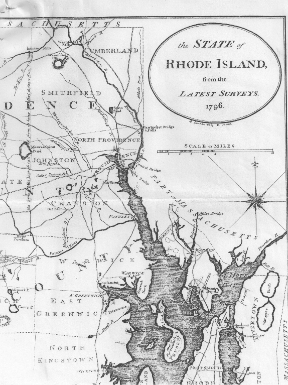
Part of a map of Rhode Island by B. Tanner, 1796. This map shows all of the area east of the Pawtucket and Seekonk Rivers as Part of Massachusetts. Today these areas comprise Pawtucket and East Providence, Rhode Island. Formerly known as Rehoboth or Seaconck, this area was the more popular route from Boston as it passed more directly to Bristol and Newport to the south. Pawtucket Bridge and Falls are shown at top center, as is the road I followed into Providence, the southwesterly road through North Providence. Note that Providence even in 1796 still is comprised of only three or four main streets, today’s Main, Benefit, and Weybosset Street. Also note the two bridges to the southeast of Providence, Central and India Bridges. These were the original Lower and Upper Providence Ferry crossings. Hamilton detoured to Providence by crossing Pawtucket Bridge then recrossing the river at India Bridge (Providence Ferry in 1744) then continuing on to Newport.
Thursday, July 15, 2010
Walking the Post Road
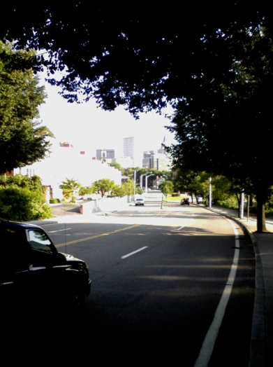
View of Downtown Providence from Main Street heading into the City from Pawtucket. This is the route Alexander Hamilton followed on his return to Maryland from Boston, crossing Pawtucket Falls over the rickety bridge first built in 1713 and replaced in 1731.
-
1.Hamilton, Itinerarium, 148.
-
2.Ibid., 149.
-
3.Birket, Some Cursory Remarks, 25.
-
4.Susan Marie Boucher, The History of Pawtucket, 1635-1986, passim.
…having made covenant of peaceable neighborhood with all the sachems and natives round about us, and having, in a sense of God’s merciful providence unto me in my distress, called the place PROVIDENCE, I desired it might be for a shelter for persons distressed for conscience;
Roger Williams, founder of Rhode Island.