Entry #30: Mile 57, Warwick, Rhode Island. Planes, Trains, Automobiles, Feet.

The term “village” in Rhode Island must be translated into American English for the rest of us. My walk through the Ocean State has taught me to be on the lookout for any place that is referred to as a village. These places are often the tranquil, pretty, and interesting parts of the walk as opposed to the noisy, ugly, and uninteresting sections, which are never in an area called a village. Village means old architecture; village means time to eat; village means art galleries; smart shops, cafes with ocean views, and air-conditioned libraries where I can take a break while I do “research” for this project, which includes using the free wifi to check the soccer scores and my email (The fact that I have no car does not mean I am a complete Luddite, or else I would not have a blog would I?). In short, village means oasis.
I must take a moment here to explain something about the nomenclature of Rhode Island towns. Especially here in the “Providence Plantations” section of Rhode Island, the cities and towns are often massive physical entities relative to the those in Massachusetts. For instance, Warwick, the city I am currently walking through, has an area of 35.5 square miles. Other towns through which I will pass are even larger. North Kingstown, for example, has an area of 43.6 square miles, while South Kingstown has an area of 57.1 square miles. By comparison none of the towns I walked through in Massachusetts was bigger than Attleboro’s 27.5 square miles, and the city of Boston fits its population of 645,000 (2009 estimate) into 43.2 square miles. Even Paris (40.7 square miles) is smaller than South Kingstown. The irony is that the smallest state has some of the biggest towns that I will visit.
Inside these towns are the “villages.” Each town has numerous neighborhoods which are often the place to which a resident will refer when asked where he or she live. A resident of Wickford will not say he lives in North Kingstown, nor will a citizen of Wakefield say she lives in South Kingstown. They know they live in the larger political entity, but on a daily basis life revolves around the villages or neighborhoods. It is thus impossible to find Pawtuxet or Apponaug, Wickford or Kingston, Peacedale or Saunderstown, Galilee or Watch Hill, Jerusalem or Frenchtown in any official list of towns in Rhode Island because they do not exist as official political entities. Which does not make them any less interesting, it just makes life very confusing for the traveler. There is no sign at the Pawtuxet River Bridge saying Welcome to Warwick, but there is a sign saying welcome to Pawtuxet Village. But Warwick, not Pawtuxet, is what pops up on the geotag that my phone puts on the photo I take of the Pawtuxet Cemetery (more proof I have entered the 21st century).
*****
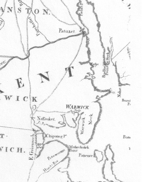
The walk through Warwick on the Post Road is essentially a walk from one village to another with a massive dose of classic Route 1 sprawl in between. I head down Post Road in Pawtuxet through the elegant colonial neighborhood and quickly leave the tranquility behind. A map from 1796 (left) shows the road I am walking today heading southwest from Pawtuxet across what was described by one traveler in the eighteenth century, the Reverend James Bailey of Portsmouth, New Hampshire, as a “flat featureless plain, almost like a desert,” until it reaches the Apponaug River and Apponaug village (called Nassauket on this map) where it turns due south and enters the village of East Greenwich (one of the few villages whose town has the same name). (1) Pawtuxet, Apponaug, and East Greenwich are the villages that bookend the long diagonal road that cuts across Warwick. Today this road is mostly US Route 1 and is named Post Road. It is nine miles from Pawtuxet to East Greenwich.
Post Road leaves Pawtuxet and intersects Route 1A after a mile, and at this point Post Road becomes one with Route 1A for another mile. Here Post Road ceases to be a two-lane road passing through a residential neighborhood and transforms into a four-lane commercial road. The traffic increases dramatically, and I begin my long slog through the “featureless plain.” Another ten minutes of walking brings me to the first Walmart I have seen directly on the post road, although one or two have been within a short walk of the road. I suspect there will be many more ahead. I will keep track as it will give me something to do when I am walking through these commercial stretches. I would count Dunkin Donuts, but I see one what seems to be every 15 yards...
Fortunately I have not had to walk much on what most people think of as the post road, which is US Route 1. It is true that for much of the remainder of the walk I will spend a lot of time on this highway, but there are many segments that have been bypassed by the highway planners that will reward me for enduring the chaotic and overdeveloped Route 1. As Route 1A intersects with Route 1, Post Road becomes Route 1 and now the real fun begins.
*****
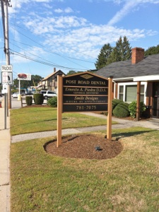
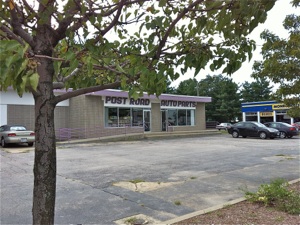
Above: You can get anything you want on the Post Road. Rather than show you Walmart or traffic, with which I am sure everyone is familiar, I present the first in a series of photographs showing businesses that have taken the name of the Post Road as their own. In addition to a dentist and an auto parts shop, I have also encountered the Post Road School in Walpole, MA and Post Road Suites, where I can find an orthodontist, a hair dresser, and someone to read tarot cards for me. A way to pass the time on the “less interesting” sections of the road.
I will argue here that walking the Post Road is better than the Appalachian Trail. I love the description of Bill Bryson’s first day out on the AT in his humorous book A Walk in the Woods: Rediscovering America on the Appalachian Trail; he has overpacked so much that he dumps a bunch of stuff down a ravine to lighten his load. I think Bryson would have had more fun on the Post Road and would have “rediscovered” America more quickly, easily, and accurately. He would not have had to pack as much because there is a CVS or a BJ’s every couple of miles (thank you Rite Aid for bandaids for my blisters), and he would have travelled in populated areas, where Americans actually live. But the thing that is the best about the Post Road in comparison to the Appalachian Trail is that the scenery changes every few minutes. I have been on sections of the AT, and I can tell you, there are a lot of trees, some views of more trees from high viewpoints, and then some more trees. The makeup of the trees changes every few hundred miles, but they are still basically trees. You are too tired from climbing up and down to pay attention anyway, so you can’t even see the forest for the trees (sorry about that, I had to do it) or birds or mammals for that matter. Don’t get me wrong, I very much enjoy nature walks and hikes. I just think that if you really want to see America, skip the AT and follow the Post Road.
*****
As the traffic roars by I can console myself that at least there is a sidewalk, which makes the walking relatively straightforward. I pass a “Chinese” restaurant that reminds me of the ones I went to when I was a kid. The teal colored “polynesian” style building looks like just the kind of place you can get a pu-pu platter, which a little research indicates is of Hawaiian, not Chinese origin. It is amazing that people from China come to the US and run restaurants where they serve Americans what they think is Chinese food, but is really some Chinese-Polynesian-American hybrid. Of course America is a hybrid amalgamation of all sorts of cultures. A lot of them can be seen here on Route 1. The next five miles present a variety of “foreign” restaurants, including Greek delis where they serve eggplant parmesan subs, a store that sells “India and Pakistan Food,” along with Bugaboo Creek Steakhouse (Canadian “Themed,” but started by a guy from Providence), Outback Steakhouse (Australian “Themed” but again, American). Then there are the “local” restaurants likes Legal Seafoods, which long ago ceased to be a proper Bostonian establishment. The irony of all these themed restaurants is that they utilize the cliches from the culture they profess to be representing, and thus do not really represent that culture in any meaningful way. Route 1 is akin to a super long Epcot, where you can have any culture you want, when you want it, only it is a mostly stylized and essentially inaccurate portrayal of the culture.
*****
Four miles from Pawtuxet Bridge I reach the transportation nexus of Rhode Island, T.F. Green Airport. This airport, although only in the consciousness of most Bostonians in the past few years as it has begun to serve as an alternate airport to Logan Airport, was actually first opened in 1931. I pass under the Airport Connector, a highway linking the airport directly to Interstate 95, which is less than a mile west of the airport running in a parallel line with Route 1. Route 1 is the commercial strip of the East Coast while Interstate 95 is its nearby sister and serves to convey goods and people more rapidly between Washington, Philadelphia, New York, Boston, and a host of other places in the megalopolis known as the Northeast Corridor. Between US 1 and I-95 are the railroad tracks of Amtrak, and at the moment a new commuter rail station is being built near T.F. Green to facilitate carless travel to this airport.
Maybe it is the car exhaust, but as I wander along this route, thinking of the unkind comments of our eighteenth-century minister, I actually start to take pride in this giant concatenation of commerce. I think about how much there is in just this stretch of road in this one town in America, and I think just how much has been built in this country in a few short decades. I personally would prefer the road to be more scenic and have fewer chain restaurants and big-box stores, but I have to tip my hat to the incredible productivity of the American worker, as well as to their capacity to patronize these establishments.
*****
After another mile of also being US Route 1, Post Road happily veers away to the right and becomes its own road for a mile or so. This is an indication that a village is approaching. I pass a pond, turn a corner, and trees and Victorian houses appear like magic. This is the village of Apponaug, named for the small river that the village straddles, which runs into Narragansett Bay. The sign tells me the village dates from 1696. This particular village is quite small, basically one street that quickly passes over the Apponaug River, a small stream that is fed by the pond I passed a few minutes ago. The view out into the bay is quite nice. The view from the train is even nicer as there is a railroad bridge that crosses the cove a few hundred yards east of the road. The railroad tracks actually run very close to the shoreline in this area before turning inland south of East Greenwich, near the border with North Kingstown crossing Rhode Island and reappearing at the coast in Eastern Connecticut.
Perhaps the presence of the tracks (which date from the 1830s) explains the apartment complexes along this stretch of the road with coastal views. One would expect there to be a series of fancy houses occupying these prime sites, but the train between the ocean and the houses must have made this area less desirable to those with money, and so I find modest apartment complexes with names like “Sea Breeze” and “Ocean View” that look like they have seen better days.
*****
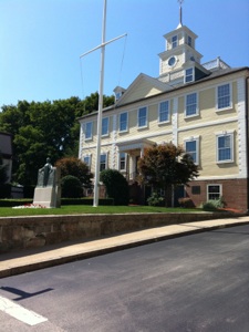
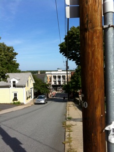
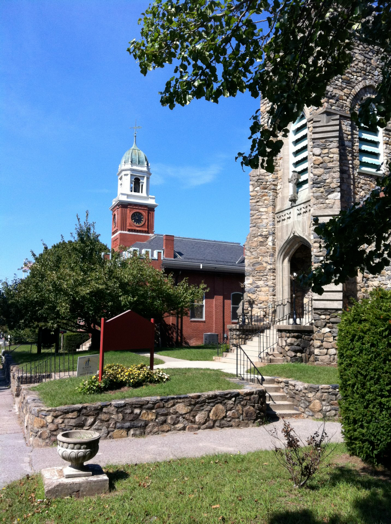
Above left is a photograph of East Greenwich Town Hall, formerly the Kent County Courthouse, built in 1804. Above right is a view from the East Greenwich Library down the hill to Main Street. The town rises steeply from Greenwich Harbor.
After almost nine miles I arrive at the border of Warwick and East Greenwich.The village of East Greenwich begins immediately at Division Street, the street on the border between the two towns. Main Street is lined with cafes, restaurants, and shops housed in an interesting and distinctive collection of buildings ranging from the Federal-era Town Hall to a Greek Revival church, to Victorian commercial and residential architecture, and an old movie house from the early twentieth century. The town was founded in 1677, a significant year in this area as it marked the end of King Philip’s War and thus the area formerly known as the Narragansett Country was lost by the former inhabitants: “Lands, titles, and jurisdiction became the property of the Colony of Rhode Island.” (2) The town seems to have been a modestly important port in Narragansett Bay in the colonial era, but its population was never very large; even by 1960 it was a mere 6,095 (today the town of East Greenwich has 12,948 people).
I take a seat at the Main Street Cafe to rest my feet after 9 miles of pretty much nonstop walking. The place is buzzing with activity, everyone seems to know each other, and the friendliness of the locals makes me wonder about the accuracy of Reverend Bailey, who claimed that not only were the people of East Greenwich “very profane and impolite,” but that the inhabitants of Apponaug were “almost as rough as the trees.” (3) Wow, this guy must have been the life of the party.
*****
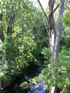
Sarah Kemble Knight traveled the same route I traveled today on October 3, 1704. She writes that “The Rode here was very even and the day pleasant....” but she also is told that there is a dangerous river that she needs to cross on the way to the next stop on the journey. According to Martha McPartland in her history of East Greenwich, the river to which she refers is the Maskerchugg River, at the south end of the village of East Greenwich. I head down a small hill and reach a small bridge crossing a quiet stream. This is apparently the river Knight referred to as the “hazzardos River” which she fortunately crossed without incident after “a few minutes.”(4) McPartland tells us that a factory referred to as “The Bleachery” was a prominent part of the river for over a century. Thus four dams can still be found on the six mile length of this short river, hence the low flow I see as I cross the river and head back into Warwick.
What? Yes, Warwick. Apparently there is a small peninsula, the Potowomut Peninsula (birthplace of Nathaniel Greene, second in command to Washington during the Revolutionary War) which has remained in the hands of Warwick down to this day. Main Street ends and Post Road begins again where it left off on the other side of East Greenwich starting with 5300 Post Road. After only a few minutes I reach the border between Warwick and North Kingstown, leaving behind Kent County and entering Washington County, the county that makes up the bottom third of Rhode Island. Except everybody refers to it as South County. Oh boy, more translations of Rhode Island geographical terminology will be necessary. I will leave the reader here at the border and pick up next time in Washington County. I am back on Post Road, back on Route 1, and the road ahead looks busy. Where’s the next village?
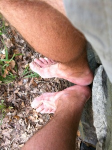
Above left: Maskerchugg River, Knight’s “hazzardos river.” Above right: sore feet.
Tuesday, September 14, 2010
Walking the Post Road
Warwick Civic Center in the village of Apponaug
“It is admirable to see what paths their hardened feet have made in the wilderness in the most stony and rocky places.”
Roger Williams, A Key Into the Language of America, Chapter XI on Travel, 68.
Notes
-
1.Esther Bernon Carpenter, South County Studies of Some Eighteenth-Century Persons, Places, and Conditions in that Portion of Rhode Island Called Narragansett (Boston, printed for the subscribers, 1924), 237. The quotes are taken from the diary of Reverend James Bailey, who traveled in the area in 1754. Born in Rowley, Massachusetts in 1732, and traveling as the companion of a wealthy baronet, Bailey seems to have had a somewhat dyspeptic personality, and eventually was forced to flee the American colonies in 1777 because of his strong Tory leanings. The diaries were edited by him and published many years later in Annapolis, Nova Scotia, where he died in 1808.
-
2.Martha R. McPartland, The History of Greenwich, Rhode Island, 1677-1960 (East Greenwich Library Association, 1960), 12.
-
3.Carpenter, 237.
-
4.Journal of Madam Knight, October 3, 1704.
-
5.Thomas Prince Lists a Drake’s Tavern in East Greenwich, 10 miles from Pawtuxet, but I have been unable to find information about the tavern. Knight does not mention the town at all, which in 1708, four years after her journey, had 280 inhabitants
Distance Covered in this entry: 10.84 miles
Total Distance covered in Rhode Island: 60.6 miles
Total Distance Covered for this Project: 129.4 miles