Entry #53: Mile 219, Darien, Connecticut. Witness to History.

The residents of some towns take pride in preserving their history while others seem to relish the idea of progress regardless of the effects it has on the character of the town. This entry takes in two towns, each of which represents one of these positions. The post road or Old King’s Highway in Darien, Connecticut has the look and feel of a nineteenth-century road. With the exception of the ten minute stretch where I crossed Interstate 95 and then passed within a few yards of US 1, passing behind the Trader Joe’s and a small shopping mall, I encountered few modern structures and little commercial activity. The road is lined with pleasant houses, many from the eighteenth and early nineteenth century. Historical plaques are scattered throughout the town, even commemorating the longevity of a tree along the King’s Highway that dates to the Revolutionary War (see photo above).
The motto of the city of Stamford, on the other hand, is “The City That Works!” and it appears by work they mean knocking down anything more than a few decades old and replacing it with large, mind-numbingly boring office buildings. I had to look very hard to find anything of historical interest in Stamford related to the post road; it seems the city leaders have, on more than one occasion as I will show, made a conscious effort to ablate the center of town and replace it with a modern version that “works.” Whether the city works or not is a matter for discussion; one thing is certain--it is without doubt the town with the fewest existing historical connections to the old King’s Highway of any town through which I have passed on the previous 300 miles of my journey and hence one of my least favorite. I hate to pick and choose winners and losers amongst the towns through which I have traveled but despite the fulsome praise longtime resident William F. Buckley lavished on the town in his introduction to a local history of Stamford, the city rates very low on my list of cities I would visit again.
*****
From the tree in the photograph above, which is near the First Congregational Church around mile 47 on Colles’s map, I walk three more miles in Darien before I reach the Noroton River which marks the border between Darien and Stamford. After a few more minutes on Old King’s Highway North I pass a red colonial-era house that is the headquarters of the Darien Historical Society. Then I pass the aforementioned small shopping plaza which is near the Darien train station on the Metro North Line. Even the station seems like it has been there for a long time (which it has; the first train stopped here on Christmas Day, 1848). In order to pass over the railroad tracks I need to take a short detour that brings me to Boston Post Road for a minute or so. This is the heart of the Darien center commercial district, and it is one of the more pleasant and low key parts of US1 I have encountered. I suppose the fact that Darien is one of the wealthiest towns in America means that development is strictly regulated. It also helps to have Norwalk on one side and Stamford on the other, both of which seem eager to build malls with gay abandon along their stretch of Boston Post Road. The people of Darien can live in their lovely town and head to the Home Depot or Walmart a couple of miles away in the next town. This is the flip side of the equation I described in the previous entry: on the one hand walking three to five miles to church in Stamford or Norwalk was onerous enough to cause the local residents to petition the legislature for a church of their own, but on the other hand modern conveniences such as automobiles make a trip of three to five miles to either town to buy a refrigerator or some groceries a snap and allows the town to maintain a strict attitude towards large commercial development.
When I regain Old King’s Highway it is now appended with the word South instead of North, indicating I have crossed the center of town. The name Old King’s Highway was not the name the road was called by the residents of what was then Middlesex Parish. In colonial Middlesex I would have walked on the Country Road. Soon after 1800 a proposal was put forth to build a turnpike from Greenwich to Fairfield which was to become the Connecticut Turnpike. Though turnpikes usually incorporated parts of the King’s Highway into their road in Darien this was done only for a mile or so from the Noroton River in Darien, after which an entirely new road was thrust through the farmland of the area, today’s US1 or Boston Post Road. The Country Road was thus left behind by progress which explains why it has maintained its winding and uncommercial character. (1) Stamford, on the other hand, saw the Connecticut Turnpike forced through the center of town, disrupting the very structure of the colonial center and even ploughing through the cemetery, none of which was very popular with residents but which occurred notwithstanding the vandalism that occurred at the construction site each night for the first few days. (2) Thus do towns start to become differentiated from each other in character. As early as 1807 Stamford center was essentially reshaped for the modern road while Darien preserved the older road and allowed the new road to pass to the north of the old town center. The early commercial center of Darien(then called Middlesex) was actually around mile 45 on Colles’s map (clearly discernible by the presence of numerous buildings along the road in the area around Clock’s Landing--see sheet 4 in the previous entry) so the Turnpike actually took in the commercial center but did not restructure the road in any significant way. (3) Even Darien, however, could not entirely escape the coming of the Interstate, which passes between Boston Road and Old King’s Highway in Darien. But as I pass over it near the train station I can see from my map that I will not approach it again until I am in Stamford.
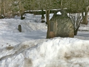
After a few minutes ambling along the pleasant old road I encounter one of those fun serendipitous historical markers that makes this project so enjoyable. At the junction of the amusingly-named Goodwives River Road, which I believe on the Colles map is the road to Long Neck at roughly mile 46, there are two stones nearly buried in the snow in a small park in the middle of the junction. The larger stone commemorates the passage of George Washington along this route on no fewer than three occasions. The smaller stone is a milestone which is almost illegible but which says at least “Fairfield” on it, and I calculate that it must be the stone indicating 17 miles to Fairfield. I mentioned in an earlier entry that the stones typically marked the distance to the county seat, in this case Fairfield County, which explains why the larger town of Stamford or even New York is not the place name on the stone. I can see across through the yards of the residences on the north side of Old King’s Highway that Boston Post Road is not far away, and the Darien Library comes into view. I stop for a couple of hours at this wonderful library, which might be the best and most comfortable library I have yet visited. Do people in Alabama and other fiscally “prudent” states not realize that it is places like this that enable the northeastern states to maintain such a large edge in Per Capita Income and educational attainment. Conservatives call it wasteful government spending; smart people call it investing in infrastructure and the future.
*****
Walking to Stamford from Darien center, clockwise from top left. 1. Bates-Scofield House, Darien Historical Society at 45 Old King’s Highway North, from 1736. 2. Two stone markers at junction of Goodwives River Road and Old King’s Highway South. The larger stone lists the three times George Washington passed this spot and the smaller stone says (although it is hard to read and almost buried in the snow) “Fairfield 17 Miles.” 3. Typical scene along the road in Darien: a beautiful house next to a creek. 4. Welcome to Stanford. View across the bridge over the Noroton River from Darien into Stamford on Boston Post Road. The big ugly buildings begin right at the border and pretty much don’t stop. The sign says “Welcome to Stamford, The City That Works!”
I return to the road after my research and relaxation period at the library. I walk for another half mile or so along a scenic stretch of road, lined with interesting houses in a wooded landscape. And then I reach the end of Old King’s Highway when it merges with Boston Post Road for the last mile or so before I reach Darien. This area is called Noroton. At the junction of Boston Post Road and Ring’s End Road I am in what was the original commercial center of Darien called Clock’s Landing, as it was near the docks of the Five Mile River. There is still a Clock Avenue nearby and the word Clock is written on Colles’s map near the 45 mile marker. As I mentioned above this segment of road is the only portion of the old road that was absorbed into the Connecticut Turnpike in what became Darien but was still technically Stamford at the time. In theory a toll would be collected at this point, but the last toll was collected in 1854 when the road, like all turnpikes, went bust and the state took control of the road that we know today as Boston Post Road or US1.
The Reverend Manasseh Cutler of Ipswich, Massachusetts coming from Reed’s in Norwalk, passed through here on the Fourth of July, 1787 and stopped “at Young’s in Middlesex, six miles, very hot and the roads excessively bad. The house is very neat but I believe not much used as a tavern.” Young’s, the only tavern on Colles’s map in what is today Darien, is shown in the Clock’s Landing area as I described in the previous entry. Cutler goes on about the “fat and lazy landlord” and generally leaves the impression that it was not worth stopping.(4) Cutler also has a go at all Connecticut tavern keepers in the same sentences in which he complains about Mr. Young: “[He] is a genuine Connecticut tavern-keeper: before your horse’s bits are out of his mouth, the usual questions are asked: What is your name? Where did you come from? And what’s your business? Answer these questions and his curiousity is completely satisfied; nor does he wish to know a syllable more about you, only that you will take care of your bill. Mine was ninepence.”(5) Echoes of the voices of Knight, Hamilton, Birket, and others over the course of the eighteenth century. I have had nothing but pleasant interactions with the various front desk staff or inn-keepers I have met in Connecticut, and most of them seem to care even less about me than Mr. Young cared about the Reverend Cutler, which is fine with me.
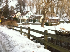
According to Kenneth Reiss in The Story of Darien, Connecticut the name Noroton derives from the word Roatan, the original name of the area when it was under the control of a sagamore named Piamikin.(6) On the Colles map the Noroton river is called the Roton River, which I would suggest shows how words become transformed over time. The Noroton River today marks the boundary between Stamford and Darien, and the difference between the atmosphere on the respective sides of the river could not be more different. The road through the Noroton neighborhood of Darien is lined with many fine old mansions set back from the road. There is even an old saltbox house which must date to the early eighteenth century, and the old cemetery sits adjacent to the river, the last of many scenic and historical sites of interest on my four mile journey through the town.
As I cross the river, the first thing I encounter are a couple of large office buildings. Although the view of the river is pleasant, the presence of so many big buildings takes away any sense of atmosphere. The road climbs a steep hill, near the top of which is a singularly ugly shiny building which, on closer inspection, turns out to be the headquarters of World Wrestling Entertainment. Maybe this ugly building is the reason Linda McMahon lost her race for the open Senate seat in Connecticut, losing even the City of Stamford.
I suppose my antipathy to the overbuilt landscape of Stamford stems in part from the stark juxtaposition of walking the Post Road in Darien and then crossing into this giant office park (because honestly that’s what it looks like). However, I also have an animus against the willful destruction of the historical landscape in the name of commerce. Sure I have encountered Walmarts and airports and auto-body shops and strip malls in other towns in Connecticut, Rhode Island, or Massachusetts that are uglier than the scene before me in Stamford. The buildings here are neat, the town is clean, there are sidewalks that have been cleared of snow, and there is a nice ethnic mix here in the city that makes for some interesting culinary options. But it is as sterile as one could possibly imagine. The road here has little of interest except where the big developers have not managed to jam in another high rise condominium or office building. Then there are at least a few stores and restaurants that are not chains.
*****
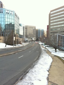
The two miles into Stamford center pass quickly as I hurry along this stretch of road, but they are not completely uninteresting in a train wreck sort of way. After the WWE building I reach the crest of the high hill I am climbing and pass over Interstate 95 again, then head downhill into Stamford. Alexander Hamilton passed here and writes “a little before I reached this town [Stamford], from the top of a stonny hill, I had a large open view or prospect of the country westward. The greatest part of it seemed as it were covered with a white crust of stone, for the country here is exceedingly rocky, and the roads very rough, rather worse than Stonnington.” (7). My view is of large office buildings, hotels, and condominiums. The roads are pretty good though. (See added footnote below)
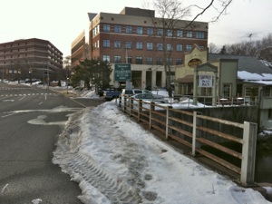
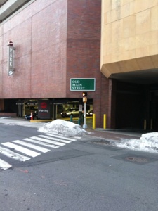
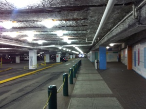
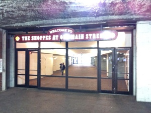
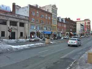
Boston Post Road (US1) becomes East Main Street in Stamford, and about a mile into Stamford, at the junction with Broad Street, US1 follows Broad while Main Street branches slightly left and downhill. As I reach the Holiday Inn Main Street becomes Tresser Boulevard, but my old map shows the original road heading due west not southwest so I know Tresser is not the way to go. I examine the maps carefully and come to only one conclusion: the Holiday Inn driveway is actually Main Street! I cross the Holiday Inn property and, sure enough, I reach Main Street on the other side of the hotel. For one block the old Episcopal church (1868) and other nineteenth-century institutional buildings hold the fort against the incessant tide of modern development, but the worst is yet to come. As I walk the completely deserted Main Street (would you walk around here?) I come to a dead end where a giant windowless concrete monstrosity of a shopping mall blocks my way. But I notice a street sign at the entrance to the adjacent parking garage that says “Old Main Street.” I cross the street and peer into the parking garage entrance with trepidation. I can see that there is a straight stretch of pavement that passes through the parking lot to the entrance to some office buildings. I walk through the parking lot and reach a glass door with the welcoming sign “The Shoppes at Main Street” (notice Ye Olde cute English spelling, always a sign of complete historical disinterest). I pass through the elevator lobby of this structure and come out into Veteran’s Square, the ignominious remnants of a once larger Central Park. Main Street continues across Atlantic Street after this humiliating passage through the parking garage and the hotel driveway and for a short block or two regains some of its dignity as it is lined with at least a few older buildings with character here in the center of the city. But it is important to remember that even here this stretch of road was a “modern” development as it was built directly through the center of town as the Connecticut Turnpike in 1807 despite the protestations of a significant portion of the residents of Stamford. As I said, this habitual urge to obliterate Stamford center goes back two centuries.
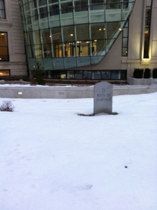
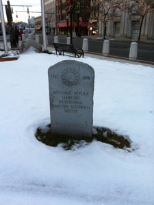
Stamford, Connecticut. Top left the headquarters of the World Wrestling Federation. Top right is the view west down East Main Street in Stamford Center. Welcome! Second Row left is the entrance to the parking garage adjacent to a large windowless, seemingly entrance-less shopping mall that takes up a huge chunk of downtown Stamford. Notice the sign for Old Main Street, which is shown at right, passing through the parking structure! Third row: at left is the exit from the parking garage at the far end of “Main Street,” which passes through an elevator lobby and then into Veteran’s Park on the west side of the shopping mall. Third row right is a milestone near the junction of Main Street and Bank Street behind the modern addition to Stamford City Hall, which says “21 miles to Fairfield.” The photograph at bottom left shows the obverse side indicating that the stone is a replica. Bottom right is a photograph of Atlantic Street from Main Street looking north. Atlantic Street is the main north-south axis of downtown Stamford, and this is one of the few blocks that was not destroyed by the F.D. Rich company as they redeveloped Stamford to make it what it is today; a faceless, soulless nowhere.
The junction of Main Street and Bank Street marked the original center of the town of Stamford. Here were located the Congregational Church and the taverns of Ebeneazer Webb and James Quintard, all of which are shown on Colles’s map. Hamilton breakfasted at Ebeneazer Webb’s, although he calls it “Weaks” Tavern. He also takes note of the newly built church, “the steeple of which was no sooner finished than it was all tore to pieces by lightning in a terrible thunder storm that happened here on the first day of August in the afternoon.” (8) George Washington called in at Webb’s as well in 1789, but compared it unfavorably to the Inn of the Widow Haviland in Rye, New York from whence he had just come. (9) Fortunately for the tavern-keeper, James Birket neglects to mention the tavern at which he “called at Stamford which is ten miles [from Norwalk] where we baited at a sorry house where we had some bad Madeira wine,” although he found the village “tollerable.” (10) Sarah Knight also mentions passing through Stamford a “well compact town, but miserable meeting house.” (11)
Indeed had the city leaders left well enough alone Stamford center could be a very pleasant place. The two or three streets that managed to avoid the nefarious plans of the developers who were handed unfettered control of the redevelopment of Stamford in the 1960s have a more welcoming atmosphere. (12) I eat in a Peruvian restaurant on the nice block of Atlantic Avenue just north of Main Street and enjoy a huge portion of well-prepared lomo saltado, a kind of stir fry with marinated strip steak and vegetables. This street and one or two more in the center have character unlike the blocks east, west, north, and south of this area. When Donald Trump has a building in your town you know it must be one ugly town.
*****
Back in Stamford center I discover one final indignity that best illustrates the Disney approach to history that exists here (exemplified by Ye Olde Shoppe-ing Malle). At the site of the old Webb tavern is a small modern square with some modern buildings mixed in with a few older buildings. In the small grass patch next to the modern addition to the old town hall at the junction of the two streets is a milestone indicating “21 Miles to Fairfield,” but even this is a mockery of the historical road as it is a replica of a milestone placed by the Bicentennial Committee in 1976. Darien had a milestone too; it was worn and faded and nearly illegible, but it was the real thing, and it blended well with the surrounding old houses and winding road. Stamford has a clearly legible milestone which gives the impression of an interest in the historical past but which is ultimately an insult to the noble and long history of the old road which passes through the town. It is almost as if to say “sorry we obliterated the town center. Here is a little token of our appreciation.” Most people might think it is goofy to stick a plaque on a tree telling the passerby that it was here when John Adams or George Washington or perhaps even Sarah Knight passed through on his or her way into history. These are probably the same people that put those signs on their houses that say things like “In 1863 at this house, nothing happened.” Willful disregard of the past is a sign of moral and intellectual decline that is a “gateway” drug to blind acceptance of the status quo or that whatever Big Brother tells you is the truth. The Horror.....the horror...(15)
Sunday, February 6, 2011
Walking the Post Road
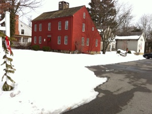
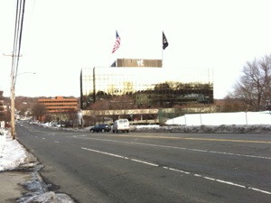
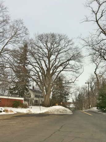
Old King’s Highway North in Darien, Connecticut. The large tree at center has a plaque on its trunk that reads “ The International Society of Arboriculture and the National Arborist Association jointly recognize this significant tree in this bicentennial year as having lived here during the American Revolutionary period, 1776-1976.”
“The road was mostly for local travel...but there were wanderers, pedestrians who walked the roads as had their predecessors through the ages: peddlers, fugitives, tramps (both male and female), the itinerant artisans with backpack or packhorse, men who dressed and sharpened millstones or tinkers who mended brass- and tin-wares.”
Kenneth Reiss, The Story of Darien, Connecticut, 45, on the post road in Darien.
Notes
-
1.Bertha Mather McPherson, editor, Darien, 1641-1820-1970: Historical Sketches (Essex, CT: Darien Historical Society in association with the Pequot press, 1970) 12.
-
2.Wood, Turnpikes of New England, 376.
-
3.Louise H. McClean, “The Eighteenth Century Tourist in Fairfield County,” in McPherson, 71.
-
4.Ibid., 56.
-
5.Kenneth M. Reiss, The Story of Darien, Connecticut (Darien, CT: Darien Historical Society, 2009), 46.
-
6.Ibid., 18.
-
7.Hamilton, Itinerarium, 169.
-
8.Ibid.
-
9.Washington, Diary, 21.
-
10. Birket, Some Cursory Remarks, 38.
-
11. Knight, Diary, 71.
-
12. Much of this story is told in Stamford 350 Years, 1641-1991, edited by Barry Hoffman et al., and published by The Advocate and the Ferguson Library, manufactured in Hong Kong. This is the book with an introduction by William F. Buckley, who freely admits to being singularly unimpressed with Stamford on his initial visit in the 1950s but who ended up there serendipitously and grew to like his home of 40 years.
-
13. Another useful book I consulted is Elijah Baldwin Huntington, History of Stamford from its settlement in 1641 to the Present Time, including Darien, which was one of its parishes until 1820 (Stamford: William Gillespie and company, 1868). I love the old titles to history books which seem to explain the whole book to you.
-
14. I have reexamined the old Colles Map around mile 43.5 and have come to the conclusion that the road may have veered around the north side of the hill over which East Main Street (US1) passes rather than climb straight over it, before the two roads merge again at roughly the junction of East Main Street and Lawn Avenue. I have marked this potential route on the map in red rather than the blue I walked. In the event Interstate 95 has obliterated a large chunk of what road might have existed from the Noroton River bridge.
-
15. Stamford was not even one of the twelve largest towns in Connecticut in 1774 even though it consisted of Darien, and parts of other towns as well as the area that is today’s Stamford. Today Stamford has about 118,000 inhabitants, making it the fourth largest city in Connecticut, after Bridgeport, Hartford, and New Haven, and the eighth largest in New England, after Boston, Providence, Worcester, and Springfield. By that standard and by the standard of economic success, Stamford is a success story. Certainly, with the exception of Boston, and perhaps Providence, Stamford has the strongest economy of the eight major cities and one of the lowest crime rates. I still think I would rather live in New Haven or Providence if I could not live in Boston. That being said, I would pick Stamford over the four remaining cities if I had to choose.
Distance Walked in the Entry: 5.26 miles
Total Distance Walked in Connecticut: 134.66 miles
Total Distance Walked for this Project (from Boston): 305.3 miles
Distance Remaining to New York: 42 miles