Entry #58: Mile 243, Mamaroneck, New York. Neutral Ground

From the corner of Mamaroneck Avenue and Boston Post Road in Mamaroneck Village, overlooking the harbor and the Mamaroneck River, it is exactly 7.9 miles to the border of New York City. This relatively short distance obscures the fact that from here to the entrance to the Bronx on West Kingsbridge Road I will pass through the Village of Mamaroneck, the unincorporated town of Mamaroneck, the Village of Larchmont, the City of New Rochelle, the Village of Pelham Manor and the Village of Pelham, and the town of Mount Vernon. Basically there is a new town, village, or city every mile along the way and most of that distance is actually spent in New Rochelle. Why are there so many small political entities here in Westchester County?
A lot of it has to do with the proprietary nature of land ownership in the New York Colony, whereby an individual was often given vast amounts of land for little money as a reward for political favors or for a promise to develop a community on the estate. In the case of Mamaroneck, Caleb Heathcote purchased 1000 acres of land in 1698, part of the holdings of Jonathan Richbell, who owned essentially everything west of the Mamaroneck River to the border of the Pell Estate, which today is the border between Larchmont and New Rochelle. Heathcote’s estate eventually formed parts of Scarsdale, Larchmont, and Mamaroneck. Interestingly, while Heathcote lived in his mansion on the hill overlooking Mamaroneck Harbor near the corner where I stand, he also served as mayor of New York in 1711, commuting back and forth by boat. (An interesting side note: Caleb’s brother Gilbert was simultaneously Lord Mayor of London; this surely must be the one and only time two brothers were simultaneously mayors of the two major English-speaking metropolises.)
Heathcote’s mansion is mentioned by Sarah Knight in the diary of her trip from Boston to New York in 1704-5. Knight, on this rare occasion, had high praise for the place: “Thence we travailed through Merrinak, a neet though little place, with a navigable river before it, one of the pleasentest I ever see- Here were good buildings, Especially one, a very fine seat, which they told me was Col. Heathcote’s, who I had heard was a very fine Gentleman.” (1) However, with the exception of Birket’s mention of “Marrowneck,” the only place that is discussed in any detail, if at all, along this route is New Rochelle.
Three reasons stand out for the relative lack of interest in the area. Firstly, most of the travelers were trying to make it to New York as quickly as possible once they were this close (27 miles to Federal Hall from this spot in Mamaroneck) and so did not linger in Westchester County. Secondly, there were not many people living along the road here. As Washington says of his journey through the area in 1789: “The distance of this day’s travel was 31 miles, in which we passed through (after leaving the Bridge) East Chester, New Rochelle, and Mamaroneck; but as these places (though they have houses of worship in them) are not regularly laid out, they are scarcely to be distinguished from the intermediate farms...” (3) Indeed, a quick look at Colles’s map of the area shows a few estates along the road from Rye, with a church and a cluster of buildings at New Rochelle (Mile 23) and East Chester (Mile 20), but not much else. A census of 1712 indicated only 84 inhabitants on the Scarsdale estate, which was the name Heathcote gave his vast property.
The third reason why later travelers at least might not have had much to say about the area is that a lot of it had been destroyed during the Revolutionary War. The area of southern Westchester County was the so-called “Neutral Ground,” an area neither under control of the British Troops controlling Manhattan Island for much of the war nor under control of the Continental Army, which was encamped in various places to the north of Mamaroneck, Pelham, and other areas along the coast of Westchester County. Instead battles were fought here intermittently between the troops of Washington and Howe, including the “skirmish” at Heathcote Hill, in October 1776 between the Delaware Battalion of the Continental Army and a regiment made up of American Loyalists called the Queen’s Rangers. Sentiments in the New York Colony were much more divided between Loyalists and Patriots than in Massachusetts, and the large landowners were, for the most part, supporters of the King. Unsurprisingly, many of these families packed up and left at the end of the War, including the descendants of Caleb Heathcote, whose mansion, so admired by Knight, was burned to the ground. Indeed, at the beginning of the eighteenth century “about 225,000 of the 300,000 or so acres that made up Westchester County were controlled by six families: Van Cortlandts, Philipses, Steenwycks, Morrises, Pells, and Delanceys, the heirs of the Heathcote’s Scarsdale.” Many members of these families were supporters of the Crown and suffered the consequences at war’s end. (4)
James De Lancey was involved in a particularly ugly aspect of the Revolutionary War in the “Neutral Ground,” organizing groups of irregular units of fighters called “Cowboys” in the case of loyalists, led by De Lancey, and “Skinners” whose loyalty seems to have been mainly to their pocketbook. These were essentially guerilla bands who wandered the territory wreaking havoc among the population that stayed behind during the war. The various local histories I read in the libraries of the towns through which I pass are full of stories of people being burned alive in their houses or beaten and killed by one group or the other. “Cowboy” is an early and interesting use of the word most of us think of as a noble sobriquet applicable to ranchers in the West, but another definition of a cowboy is “somebody engaged in reckless and aggressive behavior”, which seems to fit the description of the aforementioned units. De Lancey, like many Loyalists, ended up settling in Nova Scotia after the end of hostilities and consequently lost his large landholdings in New York.*****(see new footnote below)
*****
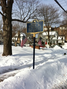
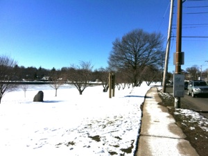
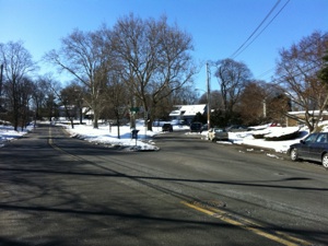
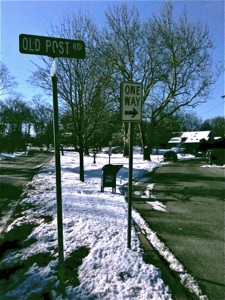
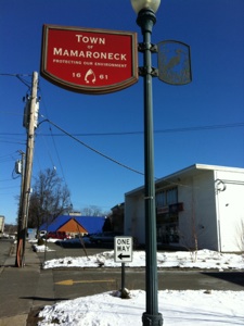
Mamaroneck, New York. Top left is a sign commemorating the “Skirmish of Heathcote Hill,” one of the many fights in Westchester County between Loyalists and Patriots, which took place on the hill overlooking Mamaroneck Harbor, October 22, 1776. Top Right is the view west on Boston Post Road (US1) in Mamaroneck on a sunny but cold day in January. At left is a park fronting the frozen harbor. The Old Post Road followed the edge of the harbor, curving south at its western shore, which can be seen in the distance. Bottom left is the place where the old road veers west after curving around the harbor. I follow Orienta Avenue left from Boston Post Road until this point, then follow Old Post Road at right which curves back around and rejoins Boston Post Road about 500 yards down the road. Between the Village of Mamaroneck and the Village of Larchmont I briefly pass through the Town of Mamaroneck, the unincorporated space between the two villages. Mamaroneck claims to be the oldest settled community in Westchester County, dating from 1661. Bottom right: there is only One Way to go -Old Post Road to New York.
Once an estate always an estate, even after the Revolution. The Heathcote/ Scarsdale/ De Lancey property was sold in the early 1790s after being seized after the war. One large piece of the estate was purchased in 1795 by Peter Jay Munro. This property was later sold to a shipping magnate named E.K. Collins, who called the property Larchmont. In 1860, Frederick Law Olmsted was commissioned to survey the Larchmont Estate and lay it out in building lots, as the establishment of the railroad and Collins’s growing need for cash had finally brought about the division of the estate into smaller pieces for the construction of summer houses for people escaping the heat of New York City. As Judith Doolin Spikes puts it in her history of the Village of Larchmont “The railroad (which began in 1848) revolutionized travel from the city and initiated the process that changed all of this area from rural farmland to suburban garden plot by the turn of the century.” (6) The development of the summer colony eventually resulted in many residents remaining year-round and the concomitant need for services such as sewers, improved roads, schools, etc., precipitated the incorporation of the area as the Village of Larchmont in 1891. Apparently there are rules regarding incorporation as a village in the state of New York: one of these rules stipulates that a village is required to have a minimum of 300 inhabitants and to have an area of at least one square mile. The summer colony apparently was a little shy of the size requirement so negotiations were made to purchase just enough land to meet the requirement, as there were about 450-500 people living in the estate already. Thus the peculiar situation whereby the Village of Larchmont is part of the town of Mamaroneck but has its own political structure and municipal services. Many locals with whom I spoke think the presence of multiple overlapping bureaucracies within the confines of some towns in Westchester County is wasteful in addition to confusing to people like me. Oh, for the old New England Town I know and love. There are no “unincorporated areas” in Massachusetts.
*****
Regardless of what the area is called today, in the eighteenth century there apparently was not much here. The town of Mamaroneck, which includes present-day Larchmont and Mamaroneck Village, had a mere 436 inhabitants in the 1790 United States Census, the vast majority of whom resided near the harbor. It is estimated that a mere 86 people lived in what is now Larchmont at the time. To get to Larchmont does not take me a long time. I walk down Boston Post Road along the edge of the park bordering Mamaroneck Harbor until the harbor ends, at which point Boston Post Road continues straight ahead while I turn left onto Orienta Avenue, in order to continue following the old road, which closely followed the contour of the harbor. After a few yards along this road, the old road branches right and curves away from the harbor. This road, helpfully called Old Post Road, passes through a residential area before rejoining the commercial Boston Post Road after a few hundred yards. I reflect as I look at the harbor one last time that I am leaving the coast for quite a few miles as the road turns slightly inland to the border with the Bronx, after which it cuts straight across the Bronx before reaching Kings Bridge, where I will see water again, this time at the Harlem Ship Channel that connects the East River and the Hudson River, all part of the vast area that is New York Harbor. In other words, this is the last time I will see Long Island Sound from the road (except for the view from my hotel room in New Rochelle, which is six stories above the ground, so not technically on the road). My constant companion for over 150 miles is now behind me as I set my sights upon New York and its impressive bay.
After a few relaxing minutes on the winding Old Post Road I rejoin a particularly boring stretch of what is here called West Boston Post Road. A sign indicates I am now leaving the Village of Mamaroneck, and a second sign a little further ahead indicates I am in the Town of Mamaroneck, which apparently is where they put all the crappy commercial development. Apparently the really bad New York drivers (redundant I know) congregate in these areas as well because I am almost clipped twice on crosswalks within five minutes by inattentive or indifferent idiot drivers of both sexes trying to get to the McDonald’s or the Starbucks in a hurry. There really is not much to say about the “Town of Mamaroneck” except that the brief section through which I walked was non-stop mini-malls and gas stations.
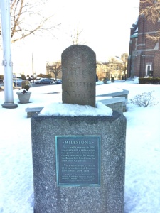
Each entity, whether town, village, or city, has a sign indicating that I am leaving or entering Mamaroneck or Larchmont or New Rochelle. These signs are quite unusual; I photographed a couple which I show below rather than try to describe them. The sign I pass now tells me I am entering Larchmont, which I can tell I have entered anyway because it immediately becomes more genteel and less crassly commercial. Old red brick buildings with florist shops replace the auto parts big box store. The center of Larchmont is quaint, and I discover another milestone on a pedestal in the town center. This milestone is 21 miles from New York, but as you may have already guessed, it belongs to the series of milestones I call the “Turnpike” milestones, and the plaque on this sign is the first I have seen that actually states this fact, saying specifically “Milestone erected in 1804, one quarter of a mile east of this point at a distance of 21 miles by way of the Boston Post Road from New York City Hall. This milestone reset in 1941 by the Board of Trustees of Larchmont, New York.” Spikes also says in her history of Larchmont that “The Westchester Turnpike roughly followed the route of the Boston Post Road but diverged sufficiently to call for the erection of new milestones.” She also says almost all of the milestones surviving today along this road are Turnpike, not Post Road, markers.(7) Thus after many miles of wandering through Connecticut and New York looking at these reddish-brown stones that do not quite match up when compared to the distances Colles shows on his accurate map of 1789, I have corroborating evidence to support my hypothesis that these stones WERE NOT PLACED BY BENJAMIN FRANKLIN. Anybody reading this who lives in any of the towns that makes this claim (and there are many!) please stop retelling this old chestnut--it is just not true. The milestones served a completely different road in 1804 from the one that existed in 1754. Besides, in all likelihood, George Washington slept,or at least ate a meal, in virtually every town along the route of the old Post Road; isn’t it enough to claim him for your town (or village or city)?
*****
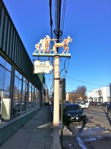
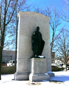
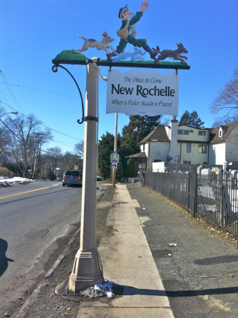
The Road to New Rochelle: top and bottom left are two signs, one at the entrance to the Town of Mamaroneck, which has a beautiful heron motif, and the other on the border between Larchmont and New Rochelle, showing an Indian family carrying a dead deer. I am not sure what that is all about but there is an even stranger sign on the border between New Rochelle and Pelham, which I show above. Top right is the milestone in Larchmont center, one of the “Turnpike” series, indicating 21 miles to New York. Bravo to the historians of the Village of Larchmont for finally getting the milestone story right. I have nothing against Benjamin Franklin, I am just irritated because that old chestnut about his laying out these milestones is tiresome the fifteenth time you read it in a local history. Bottom right is a statue of Joan of Arc at the junction of Main Street and Huguenot Street. New Rochelle was settled by French Protestant refugees who fled their homes after the revocation of the Edict of Nantes in 1685. Huguenot Street is the original street in New Rochelle and thus is the original route of the old Post Road.
On Colles’s map there are only a half dozen houses between Mamaroneck Harbor and New Rochelle. One of these, the Palmer House, was located approximately at the site of the present Larchmont Public Library in the middle of the Village, where I spend some productive hours researching the local history of the road. Leaving the pleasant center the road curves and heads downhill until it crosses a small creek at Mayhew Avenue. On Colles’s map, there is a curve just west of the Palmer House and then a small creek a short distance down the road, around mile 25. Judith Doolin Spikes (I like this book in case you have not noticed yet) spends a few pages describing some of the approximately 86 residents of the area in 1790 that is now Larchmont. She mentions Samuel Palmer, Peter Allaire, Oliver Bayley, and the Duncan family among others. On Colles’s map there is a Palmar house, a house owned by someone named “Relayer” (Allaire?), a Dunkin house (an early Dunkin Donuts?), and, a little past the creek, two places owned by the Bailey family. The Bayley house was located near the present border between Larchmont and New Rochelle. At the border I encounter an even more extravagant and eccentric sign welcoming me to New Rochelle than the signs in Mamaroneck and Larchmont(see above).
The walk from Larchmont to New Rochelle begins in a pleasant commercial center, passes through some quiet residential neighborhoods and gradually becomes more commercial, until it is completely taken over by car dealerships around the border with New Rochelle, roughly mile 24 on Colles’s map. I later learn that there is in fact another short stretch of the Town of Mamaroneck between Larchmont and New Rochelle, which explains the otherwise odd presence of so much ugly commercial development. I suspect that Larchmont is a lot like Darien, Connecticut, in that they reap the benefits of having malls and car dealerships nearby but not actually in their village, which remains prim and proper and thus maintains its desirability as a residential area along with the concomitant the high real estate prices.
*****
New Rochelle at once epitomizes the difference between New England and New York, and at the same time is a well-known place to anyone familiar with the history of Boston. The city was carved out of the estate of John Pell in 1688 for the purpose of establishing a settlement of refugees fleeing the violence that was perpetrated upon Protestants in France after the revocation in 1685 of the Edict of Nantes, which had established the right of Huguenots to worship freely in France. A center of Huguenot strength was the town of La Rochelle on the Atlantic coast of France, and the settlement of New Rochelle reflects the origins of the early French settlers, of whom “a goodly number came to Westchester.”(8) Dutch, French, English, Catholic, Anglican, Episcopal, and even Jews were mixing in New York in the seventeenth century, while Boston was a solid Puritan bloc of English people resisting the presence of even an Anglican place of worship. I find this early differential development fascinating as it seems to have persisted and perhaps explains at least in part why New York grew so much more quickly than Boston after the Revolution. On the other hand, two of the most famous early Bostonians had roots in the Huguenot community of New Rochelle: Peter Faneuil, of Faneuil Hall fame, and Paul Revere, whose family name was originally Revoire. Thus there is a spiritual link between Boston and New Rochelle that intrigues me.
After a few minutes on Boston Post Road in New Rochelle I am able to escape the monotonous car dealerships that line US1 and take a short detour on another spur of Old Boston Post Road, which passes through a residential neighborhood. After the two roads merge again a few hundred yards along the road almost immediately again splits at a junction and even US1 becomes two parts: traffic heading west heads right and up a small incline on Huguenot Street, while traffic coming from the west heading east to Larchmont travels along Main Street which is an even steeper hill. At the junction of the two roads is a small park with a statue of Joan of Arc and a small plaque that relates the history of the settlement of New Rochelle and also explains that the route of the old post road followed Huguenot Street. The plaque also notes that Paul Revere passed along this route carrying the news of the Battle of Lexington and Concord in 1775.
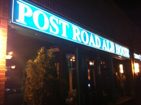
Huguenot Street is a more winding street that takes a more gradual route up this small hill, and standing here at the junction of the two streets looking at the road and at my maps, it is obvious that Main Street must have been part of the new Westchester Turnpike as it is much straighter and heads more directly uphill. Ahead of me on Huguenot Street is a vista dominated by rather large buildings that look recently built, and I have a feeling I am about to enter another “redevelopment” zone similar to that of Stamford. Fortunately it is late and my hotel is nearby so I will resume my walk in the morning. Across the street from the Joan of Arc statue is a restaurant called the Post Road Ale House whose sign is decorated with a fleur-de-lys motif. This place beckons to me like the Sirens to Ulysses so in I go and enjoy a great meal which includes a half dozen Bluepoint oysters from Long Island Sound, a sort of celebratory homage to the end of the Long Island Sound section of my walk, a cassoulet (French theme), and a couple of pints of the local brew. The Banana Cream Pie with Caramelized Banana Myer’s Rum Sauce has no connection to anything on the Post Road except my sweet tooth.
Tomorrow I will continue through New Rochelle, Pelham, and Mount Vernon, and end my brief trip through Westchester. Tonight I enjoy my meal and also try to digest the large amount of information I have absorbed about the unhappy history of the area during the Revolutionary War as well as try to get all the villages, towns, cities, and unincorporated places straight. I also toast Paul Revere and his ride along the Post Road from Boston in 1775. Perhaps he even stopped in the eighteenth-century version of the Post Road Ale House, Guion’s Tavern in New Rochelle, about which more in the next entry.
Friday, March 4, 2011
Walking the Post Road
A curious welcoming sign on the border of Pelham and New Rochelle, New York.
“Lawless bands of mercenaries ...called Cowboys and Skinners infested the ‘Neutral Ground’ ravaging the whole country between the British and American lines, a region some thirty miles in extent, embracing nearly the whole of Westchester County.”
Charles W. Baird, Chronicle of a Border Town: The History of Rye, New York in Westchester County (1871), p. 241.
Notes
-
1.Paula M. Lipsett, M.D., Mamaroneck Town: A History of the Gathering Place (Mamaroneck: 300th Anniversary of town government, 1997). I used this for a good deal of the information about the town of Mamaroneck, including the information about Caleb Heathcote.
-
2.Sarah Knight, Diary, 71.
-
3.George Washington, Diary, 20.
-
4.Judith Doolin Spikes, Larchmont, New York: People and Places, (Larchmont, NY: Fountain Square Books, 1991), 23.
-
5.J. Thomas Scharf, History of Westchester County, New York, Including Morrisania, Kings Bridge, and West Farms, Which Have Been Annexed to New York City (Philadelphia: L.E. Preston, 1886), pp177-457 passim, for information on the Revolutionary War in Westchester County and the role of the Cowboys and Skinners.
-
6.Spikes, 51.
-
7.Ibid., 14.
-
8.Scharf, 27.
-
9.After I wrote this passage a new book recently published came to my attention by Maya Jasanoff, Liberty’s Exiles: American Loyalists in the Revolutionary World, (Knopf) one of the few books to treat the Loyalists as a subject in their own right, which details the “fratricidal” nature of the Revolutionary War to which I alluded above and which previously I have not seriously considered until I did the research for this section of the Post Road. Apparently more than 30,000 Loyalists left for Nova Scotia, while thousands of others moved to far flung corners of the British Empire.
Distance Walked in the Entry: 3.5 miles
Total Distance Walked in New York State: 10.2 miles
Total Distance Walked for this Project (from Boston): 323.8 miles
Distance Remaining to New York (Bowling Green): 24 miles