Entry #42: Mile 160, Guilford, Connecticut. The "State" of New Haven.

As I stroll across Madison Green I reflect that I am now in New Haven County, which comprises most of the territory that originally made up the Quinnipiac, or “New Haven,” Colony. The New Haven Colony was founded by a group of individuals who believed that even the Puritans of Massachusetts Bay Colony at Boston were too liberal in their religious practices. The New Haven Colony favored religious rule over English Common Law and brooked no dissent from the prevailing orthodox religious attitude. Upon the restoration to the throne of the Stuart line in Britain and the reestablishment of control of the colonies by the monarchy, the New Haven Colony was the first to pay a price for its overzealous support of the Cromwellian Interregnum, particularly after three of the judges who sentenced Charles I to death were hidden in various places in the colony from the royal authorities. In 1662 the New Haven Colony was dissolved, and by 1665 had become part of the Connecticut Colony established around Hartford.
*****
What if New Haven had remained a separate colony, then a separate province, and ultimately had become a state? If we speculate that present-day New Haven and Fairfield Counties became the state of New Haven, what would that state look like today? The 1,232 square mile state (larger than Rhode Island, but smaller than Delaware) would have 1,706,575 inhabitants, according to the 2000 Census, and a density of 1,385 people per square mile, more densely populated than New Jersey (1181), and thus the most densely populated state in the Union. In terms of population the state of New Haven would rank about 37th, near West Virginia, Nebraska, and the rump state that would have become Connecticut, which also would have around 1.7 million inhabitants.
It would be a very wealthy state with pockets of deep poverty. Towns like Greenwich, Westport, and Darien have average per capita incomes (PCI) above $70,000 while cities like Bridgeport and New Haven have PCIs of under $20,000. Connecticut is already considered the wealthiest state, and the towns of Fairfield and New Haven County contain the lion’s share of that wealth, so it is fair to assume that the state of New Haven would be the wealthiest state.
The “state” of New Haven would also be one of the most liberal states despite being the wealthiest. Consider only the towns through which the Post Road and hence, I, will pass between here and New York. These fifteen towns and cities (of fifty in the two counties), which comprise the coastal portion of the “state” of New Haven, contain 876,939 people, roughly half the total population of the hypothetical state. In 2008 these towns gave Barack Obama 251,585 votes (or 65%), while John McCain received 130,062 votes (34%). McCain lost every town and city on the Post Road in the state of New Haven save Darien, which also happens to be the wealthiest town.
Lest you think that the liberal sway in our theoretical state has been dampened by the recent downturn in the fortunes of the Democratic Party, I submit the recent Senate election in Connecticut as evidence to the contrary. In the fifteen “Post Road” towns and cities, State Attorney General Richard Blumenthal defeated his challenger World Wrestling Federation Executive Linda McMahon by 151,833 votes to 98,821 votes, or 61% to 39%, beating her in every one of the “Post Road” towns and cities save Darien, as before, and Greenwich, her hometown and the second wealthiest town of the group. Thus the Republican tidal wave failed to make land fall on the Connecticut coast, especially considering that the share of votes cast as a percentage of the whole electorate in the two largest cities, heavily Democratic New Haven and Bridgeport, fell from 22% of the vote in the 2008 election to 18% of the vote in the 2010 election. I would argue that the entire difference in the Obama-Blumenthal 4% disparity can be accounted for by the simple fact that the minority vote was less active in 2010 than in 2008, rather than argue that the Republicans are doing 4% better than they were in 2008.
What do we make of the apparent contradiction in the Post Road towns? It is quite literally the richest place in America and simultaneously one of the most liberal areas of the country. Perhaps there are lessons here for pundits and politicians to discover. Even removing the total votes from the “poorest” cities of New Haven and Bridgeport, Blumenthal and Obama still won convincing victories over their opponents in the remaining towns, nine of which are over 90% white and all of which are least 65% white. Clearly neither race nor class are the deciding factors in the above elections.
The state of New Haven would contain one Ivy league school, Yale University, and the citizens of this state would also be among the most highly educated in the nation. Apparently they are incredibly stupid because if you listen to the pundits, especially those on Fox, the very people these rich, white, highly educated citizens of the state of New Haven are voting for are the root of all their problems and are transforming America into a “Socialist” state, whatever that means (I guess I must not remember all those classes in Political Philosophy I took in college very well because the definition of socialism being proffered by Glenn Beck et. al. bears little resemblance to what I learned reading Marx, Gramsci, Lenin, Mao, Owen, Bakunin, and many others). (1)
*****
But I digress. In fact I have digressed for the past few weeks as life got in the way of my trip. But now I head away from the First Congregational Church across the Madison Green, where the maple leaves have fallen while the beech and oak leaves cling to their branches for a few more days, to rejoin Boston Post Road and make my way to Guilford. The area through which I am walking is part of the Madison Green Historic District, which is listed on the Connecticut Register of Historic Places. I pass the Talcott-Bradley House from 1738, and I feel happy to be back on the road. I pass the Madison Country Club, and the road curves around the edge of the Westside Cemetery which contains some ornate and ancient gravestones. There is a farm stand on the right which has apparently closed for the season, and on the left, at 248 Post Road, is the Stone-Shelley House from 1710, which is for sale-- anyone want a big eighteenth-century house on the Connecticut Coast? Although I am on US 1 the road is fairly tranquil here. There is a small commercial district after which I take a right on Mungertown Road and then a left on Nathan’s Lane, which seems to me to be a bit of the Old Post Road which was clipped off when US 1 was straightened in the early twentieth century. Nathan’s Lane, lined with old houses, passes behind a car dealership and several stores on the main road, before rejoining Boston Post Road. I pass under the train tracks and continue through the small commercial district of West Madison before I encounter Old Post Road which branches off to the left for a few yards before curving back to the main road again, crossing US1 and going behind the stores of Boston Post Road. The winding Old Post Road reaches the East River, where I am obliged to take a detour through a marine landing. Perhaps the old crossing was ahead, as there is an old Toll House here on Old Post Road from 1831. Today the bridge across the river is a few yards to the left on US 1. There is a view of the expansive salt marsh to the south from the bridge, and I watch an Acela Express train roar across the marsh on the way to Boston.
*****
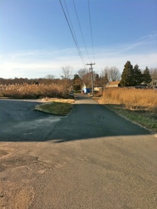
Madison, CT. Clockwise from top left: 1. Boston Post Road is tranquil and scenic as it leaves the center of Madison, curving past the Madison Country Club golf course on the left. 2. One of the many interesting and beautiful gravestones in the Westside Cemetery. 3. Farm Stand that is done for the season. Remnants of last weekend’s produce include gourds. 4. Old Post Road is a quiet lane that passes behind the commercial establishments of Boston Post Road a few yards to the left out of the picture. This road passes through salt marsh to the East River where it stops at a Toll House from 1831. To cross the river today requires a detour through a marine landing parking lot to regain Boston Post Road and cross the modern bridge a few yards to the left of the old crossing.
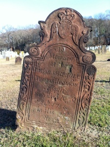
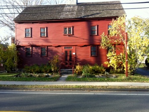
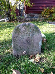
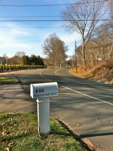
Across the East River I enter the town of Guilford, established in 1639. From here it is two miles to Guilford Center, about a 30-40 minute walk. The first ten minutes are on Boston Post Road (US 1). Then I reach Boston Street, which heads directly into Guilford Center. This road is the original road to Guilford; maps I have studied from the nineteenth century do not show US 1 as a road from this point. The Boston Post Road (US 1) that now passes north of Guilford Green did not exist before at least 1893. I pass yet another dead animal on my way into Guilford Center, this time an opossum. After a few minutes I approach the large and elegant Guilford Green. Before I reach the Green I pass the Thomas Griswold House at 160 Boston Street from 1774, then at number 80 Boston Street I reach the Hyland House Museum from 1690, scheduled for demolition in 1916, but saved and now serving as a museum. In front of the house is a small red sandstone milestone which says NH XVI. According to Henry P. Sage, in an article in the Papers of the New Haven Colony Historical Society, this stone, along with the one I discovered in New London, as well as the stone in Saybrook and Clinton, are part of a series set up by the Dragon Turnpike Company in 1817. (2) As the route to New Haven had by this time been shortened to some degree by bridges, and newer and straighter roads, the distances do not accurately reflect the distance I have yet to travel. But they are nevertheless fun to encounter and are an artifact marking a stage in the development of transportation along the Boston to New York Corridor.
Guilford Green is a large swath of park space surrounded by elegant residential and commercial buildings. There are still a few hours to go in the day, but I will stop at the library for a little research before continuing on my way. Thus I will end this entry on Guilford Green, and resume next time with my walk to Branford. In a day or so I will reach New Haven, capital of the state of the same name. I sit on a bench on the green and reflect that the little state of New Haven (although bigger than 14 or so smaller states) would get two senators, just like Wyoming, Alaska, North Dakota, South Dakota, Vermont, and other small (in population) states. Maybe there is still time to create a fifty-first state.
It makes you realize what a random institution the United States Senate is: had Dakota come in as one state instead of two, for instance, the entire balance of the United States Congress might have shifted based on a population of little more than half a million people, smaller than the city of Boston. While states like California, with 36 million people, and Texas, with 24 million people, have but two representatives, the half million people of Wyoming and the 600,000 citizens of Vermont have as much power and influence as 60 million people, one in every five residents of the country. And the District of Columbia, which has more people than Wyoming, has exactly NO say whatsoever in the running of the country, as they are unrepresented in Congress. Maybe everyone with an axe to grind should start a statehood movement for his or her county or town; when his area becomes a state, his senators can hold up international treaties or stop the president’s cabinet from being filled for years just so their local projects can get funding. Massachusetts, my home state, is moderately large but getting relatively smaller all the time, so this is not the justified carping of a resident of Houston or Fresno. If the Seventeenth Amendment was passed to change the way Senators are elected, it seems reasonable to review the rationale for two Senators in each state. Perhaps when all the states were closer in relative population this seemed reasonable, but the current state of dysfunction can at least partly be laid at the feet of the Founders, who may not have thought through the consequences of giving a citizen of Wyoming seventy times more political clout than the average citizen of California. To put it another way, it is as if Wyoming has seventy votes for each vote California gets.
The scenery is too beautiful to let this injustice mar my day. New Haven is not a state, it is just a county or two in a state. “What if” scenarios never solve problems, they just end up aggravating me. Time to go to the library and sink back into the “simplicity” of eighteenth-century Colonial America. I think I will go look at some old books about Guilford.
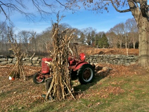
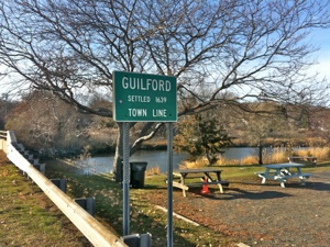
The road to Guilford Green. Clockwise from top left: 1. Old New England: An old tractor in front of a stone wall. 2. The East River marks the border between Madison, formerly East Guilford, and Guilford. 3. A milestone from the “Dragon Turnpike Series” between New Haven and New London, most likely erected in about 1817. This one says NH XVI, or New Haven 16 miles. 4. Hyland House Museum, 80 Boston Street, near the Guilford Green, dates to c. 1690. A 300 year-old house-- think about that-- it is older than the city of St Petersburg in Russia, and nearly as old as the Taj Mahal or the Palace at Versailles!
Tuesday, November 30, 2010
Walking the Post Road
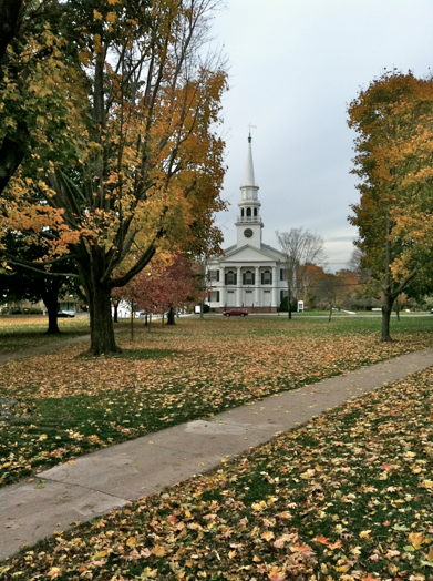
Guilford Green and Church, Guilford,CT
“The Senate of the United States shall be composed of two Senators from each State, chosen by the Legislature thereof, for six Years; and each Senator shall have one Vote.”
Article I, Section 3 of the United States Constitution. Note that the words “chosen by the Legislature thereof” were superseded by Amendment XVII, which replaced the above words with “elected by the people thereof.”
Distance Walked in the Entry: 4.78 miles
Total Distance Walked in Connecticut: 64.03 miles
Total Distance Walked for this Project (from Boston): 234.6 miles
Notes
-
1.My analysis is based on the 2000 US Census, the results of the 2008 and 2010 elections as reported by CNN and the New York Times, the Hammond World Atlas, and the 2010 World Almanac, with an occasional assist from Wikipedia. I created the “state” of New Haven by assuming that the towns settled by members of the New Haven Colony, which were primarily in what are now Fairfield and New Haven Counties, would have remained part of a single colony throughout the following century of Colonial America and into the Revolutionary War, when the New Haven Colony would have been a distinct member of the Continental Congress as were the extant thirteen colonies which eventually formed the United States of America. My purpose is not to advocate for statehood for Southeastern Connecticut but rather to illustrate the absurdity of taking a randomly formed chunk of land and bestowing on each piece of territory an equal number of senators regardless of the population contained within the borders of said “state.”
-
2. Henry P. Sage, “Ye Milestones of Connecticut,” in Papers of the New Haven Historical Society, Vol. X (New Haven: Printed for the Society, 1951), pp. 1-101, passim. Specific mention of the Hyland House Stone, number 16, is on page 60.