Entry #63: Mile 262, Central Park, New York. A Walk in the Park.

As I enter Central Park, the old road disappears for one of the very few times along the course of this project. I found the road in a shopping mall in Stamford, Connecticut, in the Bronx and upper Manhattan, in Downtown Boston, Providence, and New Haven. I found the road in a forest in the middle of the Moose Hill Wildlife Sanctuary in Sharon, Massachusetts, and I found the road in innumerable areas where it was supposed to be long gone. Here in Central Park--in the green heart of Manhattan, designed and created by Calvert Vaux and Frederick Law Olmsted in the years 1858-1873, a place full of elegantly constructed rustic landscapes replete with winding paths, a place in which it might be supposed the designers would have taken the natural contours of the road into account and kept the old road as a memory of a more rural New York--the old road was completely obliterated. I live less than a ten minute walk from Olmsted’s great contribution to Boston’s green space, the majestic Emerald Necklace, and I live twenty minutes by foot from Olmsted’s house and studio, and I am deeply impressed by the numerous contributions Olmsted made to seemingly every urban landscape in North America, from Mont Royal Park in Montreal to the US Capitol Grounds in Washington, from the design of Stanford University and numerous other college campuses, to the design of the Vanderbilt Estate in Asheville, North Carolina. Yet I would be remiss if I did not say that I am extremely irritated that Olmsted and Vaux did not spare the old road here and incorporate it into the design of the park, opting instead to redesign the already rugged landscape here at the north end of the park in a whimsical manner to suit their own aesthetic interests.
Fortunately the map produced by J.H. Colton in 1836 of Manhattan Island shows the old road as far as 92nd Street and Fifth Avenue, where the road leaves what is now Central Park and follows a winding route through the East Side of Manhattan. Sadly here too the old road has been obliterated by the steady march of the ‘Grid’ up the island. By using a combination of Colton’s map and Colles’s map of the road drawn in 1792, I am able to at least determine where the road once was, and thus in this entry I will attempt to follow the road that isn’t there from 110th Street and Lenox Avenue to Madison Square at the junction of Broadway and 23rd Street. As the crow flies this is a distance of a little over 4 miles but is closer to 5 miles on Colles’s map and will be closer to 5.5 miles as I try to follow the old road as closely as possible on today’s roads.
*****
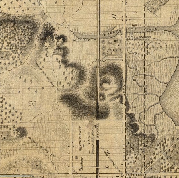
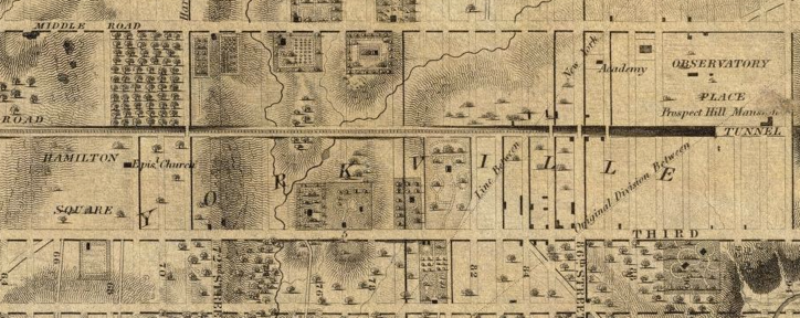
Above is a section of Colton’s 1836 map of Manhattan. The curving road heading south from near 106th Street is the old Boston Road or Old Post Road. Notice that it stops at 92nd Street and Fifth Avenue, at Observatory Place. From here to 23rd Street the road is no more, a victim of the development of the grid pattern of streets. The faint lines of the planned grid are superimposed on the landscape of 1836 in this map, along with the heavier lines of roads already built, all of which enables me to use the map like a piece of graph paper to identify the twists and turns of the lost road. The Harlem Creek at the top of the map was transformed into the Harlem Meer in the northeast corner of Central Park by Olmsted and Vaux, effectively submerging the road between 106th and 109th Streets, in the 1860s.
The old road, which now follows St. Nicholas Avenue in Harlem, once passed through what is today the intersection of 110th Street and Lenox Avenue, and continued in a southeasterly direction for two blocks, where the road crossed the Harlem Creek. Here a second road headed east towards the old village of Harlem, shown on both Colton’s map and Colles’s map. At this point, roughly halfway between today’s Fifth and Sixth Avenue at 108th Street, the road started due south through a rugged area of steep hills. The road passed through the middle of two fortified hills, Fort Clinton on the eastern ridge and Fort Fish on the western hill. The area through which the road made its way between the hills was called McGown’s Pass, after a tavern shown on Colles’s map at about mile 7.5 along the road. Today there are still traces of Fort Fish and Fort Clinton, and there is still an area called McGown’s Pass in Central Park, just south of the Harlem Meer, a lake created by Olmsted and Vaux from the marshy waters of the Harlem Creek over which the road once passed. The lake covers the old road from 109th Street to 106th Street today, and I am obliged to walk around the western shore of the Harlem Meer to reach McGown’s Pass.
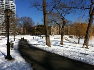
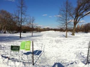
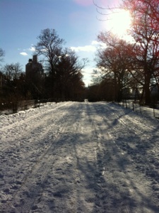
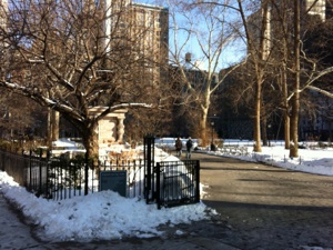
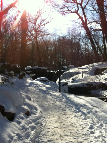
Recent snowfall (I passed through here in January) has transformed the park into a bright winter wonderland, and many people are taking advantage of a cold but sunny Sunday afternoon to go sledding, skating, and skiing, or to have a snowball fight, or just to walk through the park. Even the northeast corner of the park is heavily used, and it is estimated that over 30 million visits to the park occur every year, making Central Park one of the most visited parks in the world. I pass the Lasker rink, and the path twists and turns through a rugged landscape past the sights of Fort Fish and Fort Clinton. From here I follow East Drive as it winds south--this is the closest approximation to the old road, which similarly wound its way south for about 15 more blocks. On my right starting at about 97th Street is the Jackie Onassis Reservoir, which I remember from the movie ‘Marathon Man’ with Dustin Hoffman. New York is like that--places I have never before visited are instantly familiar because of their association with a movie or a television show--I could probably write a whole entry dedicated only to sites along the Post Road in New York which have featured in films and television.
*****
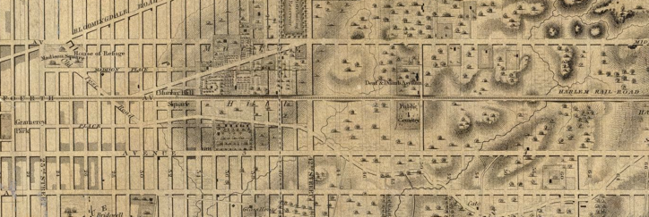
In another ten minutes I have completed the roughly one mile walk through Central Park and emerged onto Fifth Avenue at 92nd Street, opposite the Jewish Museum at the edge of the grid. The famous New York grid plan was the product of the ‘Commissioner’s Report’ to the New York State Legislature in 1811, a plan for the orderly development of New York City from 14th Street to Washington Heights in the northern part of Manhattan. At the first census in 1790 New York, with a population of 49,401, officially became the largest city in the nation, a position it has yet to relinquish and probably will not relinquish for a very long time. By 1810 the population had already reached 119,734 with no signs of abating, so the bureaucrats of New York came up with the above plan to allow growth in the city to proceed in a logical manner. At the time of the first plan, Central Park was not envisioned, and the grid was drawn to include the area that is now Central Park. One of the few areas that was left open was a stretch from 89th to 94th Street between Fifth Avenue and Park Avenue which was called Observatory Place. This area, also shown on Colton’s 1836 map, was, according to Valentine’s Manual for the City of New York, 1916, intended by the commissioners to be “a space sufficient for a large reservoir, when it shall be found needful...to furnish the City with a copious supply of pure and wholesome water.” (1) In the event, the reservoir was built slightly to the east, in Central Park, and the area around Observatory Place became a part of the grid while the area west of Fifth Avenue to what was then Eighth Avenue and from 59th Street to 110th Street became Central Park.
The grid was criticized from the beginning, with one critic commenting that the planners “ would have cut down the seven hills of Rome.” Indeed the plan was produced without regard to topography and with a regularity that many found soul deadening: 155 blocks of streets, 20 blocks to a mile, twelve north-south avenues. Only the area below 14th Street, Broadway, and St Nicholas Avenue were allowed to maintain any sense of irregularity and the grid was eventually extended beyond 155th Street and even into the Bronx. The Old Post Road was probably the most significant casualty of the grid plan, at least from Madison Square Park at 23rd Street to 110th Street, where it disappeared under the onslaught of regimented development.
Most of Manhattan north of Madison Square was farmland, meadows, or woods well into the nineteenth century (see quote above), and the area east of Central Park through which the Post Road once ran was no exception. The earliest development of this area, now called the Upper East Side, was along the bluff overlooking the East River, where many mansions were built, including the current residence of the mayor of New York City, Gracie Mansion (built 1799) at 88th Street. By 1837 the New York and Harlem Railroad had been built along the line of today’s Park Avenue and slowly development followed. Many wealthy residents of New York built mansions along Fifth Avenue overlooking Central Park, following the Vanderbilts, whose mansions(!) along Fifth Avenue at the southeast corner were followed by construction of many of the mansions of the famous Gilded Age. The famed era of opulence was short-lived as apartment blocks began to replace the mansions as early as 1907. Meanwhile, the areas further east, on the ‘wrong side of the tracks,’ were occupied by a multitude of working-class residents speaking many different languages. By the twentieth century many of the streets of the East Side became identified with particular ethnic groups: ‘Bohemians’ (Czechs, Poles, Slovaks) on 72nd Street, Hungarians on 79th Street, Germans on 86th Street, with Irish and Jews scattered liberally throughout the neighborhoods.
*****
Underneath the modern grid is the Old Post Road, paved over by the inexorable growth of the city northward during the nineteenth century. The maps I have studied, described above, are my guide to follow the path as best I can through the geometric precision of this area of New York City. On Colton’s 1836 map the road stops at Fifth Avenue and 92nd Street but resumes at Third Avenue and 66th Street. Thus I need only recreate the 26 block long and 4 block wide stretch running through most of the Upper East Side. Fortunately the longtime Curator of the Museum of the New York Historical Society, Richard Koke, published an article in which he recorded the location of the colonial-era milestones as accurately as possible.(2) Stewart Holbrook interviewed Koke in his 1962 book on the Post Road and also described the location of the milestones.(3) I have placed these milestones on my own map, shown below as green pins. On the map I also have tried to recreate the old Post Road as accurately as possible using the maps at my disposal. The original route is the blue line, while the green line is the actual route I walked to hew as closely as possible to a curving road on a geometric grid.
The road from milestone seven to milestone six was fairly direct and essentially cut a diagonal from what is today Fifth Avenue at 92nd Street through to Third Avenue at 81st Street. From milestone six to milestone five, at 62nd Street and Second Avenue, the road roughly followed what is today Third Avenue, curving sharply at about 66th Street towards Second Avenue. From this point the road can be traced using Colton’s map of 1836, which shows the blocks of the Commissioner’s Plan superimposed on the original road, which was soon to disappear. The first mile (seven to six) will be virtually impossible to do except by zigzagging through the Upper East Side, while the second mile (six to five) can basically be accomplished by walking down Third Avenue. So off I go into the Upper East Side.
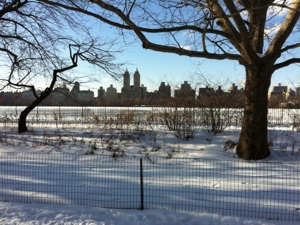
Above are views of Central Park taken as I walked along the rough path of the Old Post Road. Above left is a map that recreates the walk I did as well as shows the actual route of the Old Post Road. Below is a section of Colton’s 1836 map showing what is today the Upper East Side. Note that in this orientation the avenues run from left to right and the streets run from top to bottom. At upper right the post road is visible coming in to Observatory Place, reappearing at the bottom left corner at Third Avenue and 66th Street near the proposed Hamilton Square (which was never built). Note also that the name Yorkville is given to the entire area, although today Yorkville only applies to the area above 72nd St. The road followed a line from 92nd Street and Fifth Avenue to 81st Street and Third Avenue, roughly along the line of the stream visible in the center of the map, then headed roughly down Third Avenue, crossing the stream at about 75th Street. Colles’s map shows the road crossing a stream halfway between milestone five and six.
How different the Upper East Side is from Harlem! I have merely crossed through a twenty block section of Central Park, but the change could not be more dramatic. As I leave the park through the 90th Street gate and cross Fifth Avenue, elegant apartment buildings and museums line the street as far as the eye can see. This area is part of census tract 15002, which is composed of 97% White Non-Hispanic residents, the first time there have been a majority of white residents on the road since I was in Pelham (around mile 22). The median household income of this census tract is close to $200,000, not the highest in New York, or even on Fifth Avenue, but at least 10 times higher than the income of the census tract at Lenox Avenue adjacent to the place where I entered Central Park. I meander through the Upper East Side in a zigzag pattern, east on 90th Street at Fifth Avenue to Madison Avenue, then south on Madison Avenue for two blocks, then east on 88th Street to Park Avenue, which I follow south for two blocks, then east on 86th Street to Lexington Avenue, which I follow for four blocks to 82nd Street, where I cross over to Third Avenue.
To be honest, this area seems a little dull, which surprises me, as I expected to be excited by the architecture and the vibrant street life. Instead, although the apartment buildings are nice enough, there is not a lot of street action. Third Avenue, in particular, is a bland collection of chain stores and restaurants. Eighty-sixth Street, the heart of the German community in Yorkville, is nothing to write home about either, although it is possible that the action is further east, beyond Third Avenue. Maybe it is like the saying “It’s a great place to live, but I wouldn’t want to visit”; that is, it is a comfortable place to live but there is not much to see. Most of the area is overwhelmingly white and prosperous: indeed none of the census tracts through which the old road once ran has a population that is under 73% White Non-Hispanic. There are lots of restaurants of the type that are patronized by Jerry Seinfeld and friends on the TV show, and there is the occasional cafe that looks interesting, but there is nothing to detain me from continuing on my way.
I follow Third Avenue from 82nd Street down to 64th Street and remain unimpressed, except at 65th and Third Avenue, where I find some evidence for the existence of the Post Road. On the corner of a building is a plaque commemorating the purported site where Nathan Hale was hanged by the British for espionage in 1776, at which he is reputed famously to have said “I only regret that I have but one life to give for my country.” The plaque cites the diary of a British officer as stating that Hale was hanged at the Royal Artillery Park near the Dove Tavern on the Old Post Road at what is today 66th Street at Third Avenue. On Colles’s map there is an Adamson’s Tavern at roughly the same place as the Dove Tavern would be found, just above the five mile stone. Except for this scant piece of evidence there is little along the next couple of miles to indicate the road ever existed.
*****
At 64th Street I walk one block east to Second Avenue, which I follow for fourteen blocks before returning to Third Avenue at 50th Street. I then follow Third Avenue to 43rd Street and then head west one block to Lexington Avenue, which I follow from 43rd Street to 29th Street, crossing Murray Hill. Finally, I walk west to Park Avenue, then south two blocks, then west again to Madison Avenue and south one block to the northeast corner of Madison Square Park. Even the above description sounds boring. To be fair, the scenery of the city itself is quite interesting, but the connection to the road is absent so I do not feel any link to the surroundings and feel as though I am just wandering aimlessly through Manhattan and could essentially choose any route to reach this spot. Another problem is that there is literally so much stuff within a block or two of the road that I could write forever about many aspects of history and culture and never exhaust the topics along the road. This is best left to other blogs, in particular the excellent website and podcast The Bowery Boys.
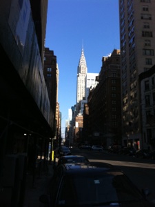
At Third Avenue between 45th and 46th Street would have been milestone number four, and along the next few blocks of the route I pass two of my all time favorite structures along the route, the Chrysler Building at 42nd Street and Lexington Avenue, and Grand Central Station at 42nd Street and Park Avenue. In the last stretch from 42nd Street to 32nd Street I climb Murray Hill, which is shown on Colton’s map and is also the name the neighborhood is known by today. On a personal note, my grandmother once lived in the area around 37th and Park Avenue. My most vivid memory of visiting her when I was a boy was of the view straight up Park Avenue as I walked out of the door of her apartment building, with the Pan Am building (now the Metlife building) and its distinctive logo looming over the amazing Grand Central Station, which seemed to float in the air over the middle of Park Avenue. The memories of the skyscraper, with its helicopter landing pad on the roof, were sealed permanently in my mind at the age of twelve, in 1977, when we visited my grandmother shortly after moving to the United States and shortly after a helicopter crashed while landing on the roof, killing five people, including a pedestrian on 43rd Street who was killed by one of the falling blades. They stopped the helicopter service after that event.
*****
Finally, I reach Madison Square Park where, at the northeast corner on 26th Street, the third milestone once stood. On Colton’s map of 1836 the road leaving Madison Square Park is clearly labeled ‘Old Post Road.’ The road can also be seen extending southwards out of Madison Square. Happily for me, this section of the old Post Road is still extant in Manhattan for the final three miles from Madison Square to Bowling Green. The end of the walk will salvage what would otherwise have been a dispiriting end to this project. I would not have been able to muster much enthusiasm to follow the ‘ghost road’ to the end of the island, but, as the actual road is still there, I am excited to follow the last piece of the old road from Boston to its terminus and conclude my walk.
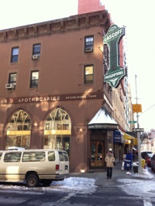
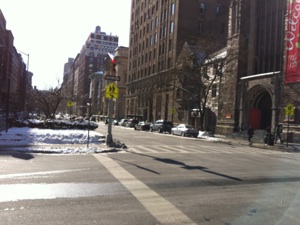
Above is a section of Colton’s map of New York from 1836. This section, again with north to the right and west at the top, shows the Old Post Road from 66th Street and Third Avenue to Madison Square. The road is clearly labeled as it heads northeast from Madison Square. Below are scenes along the route from Central Park to Madison Park: Clockwise from top left: 1. Lascoff’s Drugs at Lexington and 82nd Street. 2. A view down Park Avenue from 85th Street. 3. Looking down Lexington Avenue to the Chrysler Building, possibly my all-time favorite skyscraper. 4. Madison Square Park, roughly three miles from the end of the road.
Wednesday, April 13, 2011
Walking the Post Road
A path through Central Park roughly along the route of the original Boston Road. The road was obliterated from 110th Street to Madison Square at 23rd Street. The old road passed through what is now Central Park for about twenty blocks, from 110th Street to 92nd Street, before continuing through the Upper East Side.
“After leaving Twenty-seventh Street and Third Avenue the traveler was in the country. There was no other settlement until Yorkville was reached, nearly two miles beyond.”
Description of a trip to Harlem in the 1840s by John F. Mine in A Tour Around New York, 1893, 234.
Notes
-
1. David Thomas Valentine, Valentine’s Manual of the City of New York, 1916 edition, (New York: Valentine Company, 1916), 114.
-
2. Richard J. Koke, “Milestones Along the Old Highways of New York City,” New York Historical Society Quarterly, 34 (July, 1950), 165-89.
-
3. Stewart H. Holbrook, The Story of the Old Post Road, (New York: McGraw-Hill, 1962), 243.
Distance Walked in the Entry: 5.52 miles
Total Distance Walked in New York State: 32.4 miles
Total Distance Walked for this Project (from Boston): 346.1 miles
Distance Remaining to New York (Bowling Green): 3 miles