Entry #61: Mile 253, Manhattan, New York. The King's Bridge.

Marble Hill is the answer to one of the classic trivia questions: what is the only neighborhood in Manhattan that is part of the mainland? The neighborhood, immediately south of West 230th Street, once was part of York, or Manhattan Island, and was an area that was crossed by every visitor to New York who traveled by land. This is because the sole bridge connecting the island to the mainland was built here in 1693, across a creek called Spuyten Duyvil, The Devil’s Whirlpool, or “Spitting Devil.” The name, of Dutch origin, refers to the somewhat turbulent waters that characterized this convoluted meeting of the waters of the Harlem and Hudson Rivers. Not surprisingly, it was difficult to cross. As the narrowest crossing to the mainland, however, Spuyten Duyvil was destined to become an important transit area, and by the 1690s demand for a bridge to cross the tempestuous waters was high. The local landowner Frederick Philipse (originally Vriedrick Flipsen) took on the project of building a bridge across the creek from Manhattan to his property on the mainland in what is now the Kingsbridge neighborhood of the Bronx in 1693. Philipse did not build the bridge as a magnanimous gesture to the people of New York: as Sarah Knight indicated in 1704, the bridge was a profit-making enterprise: “about 5 we come to Spiting Devil, Else Kings bridge, where we pay three pence for passing over with a horse, which the man that keeps the Gate set up at the end of the Bridge receives.” (1) A second bridge, which was free to cross, was erected nearby in 1759 by Jacobus Dyckman and Benjamin Philips in response to numerous complaints by farmers about having to pay the toll. Both bridges are gone today, as is the Spuyten Duyvil Creek.
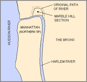
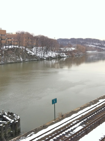
The creek was filled in after a larger ship channel was carved out of a preexisting small brook that roughly paralleled what would be 223rd Street. This canal, which obliterated the grid from 220th to 224th Street, allowed the passage of ships from Long Island Sound to the Hudson River. The outline of the former Spuyten Duyvil Creek remains only in the boundary line separating Marble Hill from the Bronx. Below is a map detailing the geographic changes to the area.
Manasseh Cutler’s biting remarks probably reflected the consensus opinion about the bridge: it was not particularly noteworthy except that everybody had to cross over it. There may still be a piece of the bridge under the asphalt near 230th Street and Kingsbridge Avenue, otherwise the bridge disappeared with the creek, leaving only the neighborhood name as a legacy. But it was almost always mentioned by travelers who had to cross it. (2)
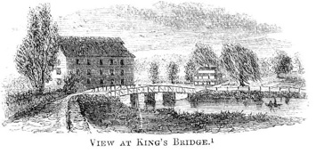
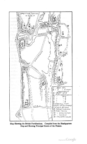
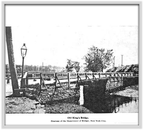
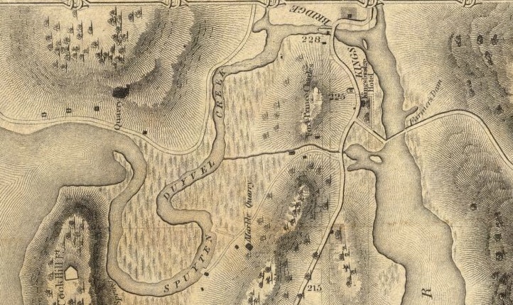
King’s Bridge and Spuyten Duyvil. Below left is a map from Jenkins, The Story of The Bronx (1912, p.129) depicting the location of fortifications but also showing the various waterways and roads that crisscrossed the area of upper Manhattan and the Kingsbridge neighborhood of the Bronx. Broadway still exists, although Spuyten Duyvil creek was filled in shortly after his book was published. Below right is an image of unknown provenance showing King’s Bridge during the Revolutionary War. The image at lower right shows the original course of Spuyten Duyvil and the neighborhood of Marble Hill, part of Manhattan but now on the mainland. Bottom left is a photograph from Jenkins showing King’s Bridge as it looked in the late nineteenth century. Finally, the map at the very bottom is an excerpt from an 1836 map of New York, which shows the planned numbered streets of the city alongside the actual terrain and streets of the time. The small creek between 222nd and 223rd street was enlarged to create the Harlem River Shipping Channel in 1895. King’s Bridge is between 228th and 230th Streets, while the Dyckman Bridge was at 224th Street.
*****
The area around King’s Bridge, in what is now the Bronx and in what is today Upper Manhattan, is characterized by steep hills, thus the old Post Road in this area seldom follows a direct line. The route leading to King’s Bridge, as I mentioned in the previous entry, followed the curve of Albany Crescent before making one final swing northwest to reach the bridge. After crossing over the bridge, the road curved to the east around what is today Marble Hill. On the maps above one can see that the hill was the site of Fort Prince Charles. After a few minutes walk the traveler would arrive at the second bridge over the river, the Dyckman Bridge, from which lead the road to Westchester, today called, confusingly, Kingsbridge Road. Near this bridge stood Hyatt’s Tavern, roughly at the fourteen mile mark, shown on Colles’s map of 1792. George Washington visited the tavern twice on his journey to New England in 1789, the first time on the first day of his journey, Friday October 15th, when he “arrived at the house of one Hoyatt (sic), who keeps a tavern at Kings-bridge, where we, that is, Major Jackson, Mr. Lear, and myself, with six servants, which composed my retinue, dined.” On the last day of his travels Washington “breakfasted at Hoyet’s (sic) tavern, this side of King’s-bridge, and between two and three o’clock arrived at my house at New York, where I found Mrs. Washington and the rest of the family well.” (3)
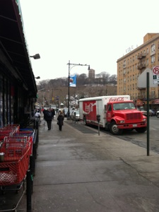
Today Hyatt’s would be at about 225th Street and Broadway, where the present bridge over the Harlem River is situated. Crossing the Harlem River is a true watershed as I finally reach the Island of Manhattan on the other side. Although neither this bridge nor this section of the river existed here in the eighteenth century, the crossing will have to make up for the absence of both the King’s Bridge and Spuyten Duyvil Creek over which it passed. The walk from the original site of King’s Bridge to the northern tip of Manhattan Island today is not particularly interesting. King’s Bridge is near the uninspiring Marble Hill Housing Project, after which I follow Marble Hill Avenue for one block to 228th Street, presumably crossing Spuyten Duyvil Creek in the process. Ahead of me is the steep incline of Marble Hill, but I follow 228th Street as it curves around Marble Hill, until it reaches Broadway. At 225th Street and Broadway I head up and over the Broadway Bridge, with the whole of Manhattan Island before me.
From the very top of Manhattan Island to the end of the road at Federal Hall is about 14 miles. The first three miles are very straightforward-- I merely follow Broadway as it winds its way south, the ancient route that made its way through the steep hills of the area literally taking the path of least resistance. A cursory glance at any of the maps above shows Broadway then as now, sweeping southwest in a wide arc before turning southward. I will follow Broadway from 220th Street at the very tip of Manhattan to 169th Street, near Columbia Presbyterian Medical Center, when Broadway becomes part of the grid for a few miles. I will rejoin Broadway only in the last mile or two, instead following the original route through Manhattan as closely as possible. For the route through Harlem, the old road is St. Nicholas Avenue, which I will follow to Central Park, after which the route becomes hard to follow as I will describe later. Only when I reach Madison Square does the old road reappear, and I will then follow it the final two miles to the end of the road.
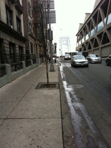
At 216th and Broadway the elevated lines of the Number 1 train veer off straight down 10th Avenue as Broadway continues its curving route to the southwest. To my right the landscape rises sharply from Broadway to the lofty heights of Inwood Hill. Ahead I see more high areas, and to my left the land slopes sharply down to the Harlem River. The contours of Broadway make sense now that I am walking the road. One thing I had not previously appreciated about Manhattan is just how high up some of the areas in Upper Manhattan are: Inwood is over 150 feet high, and the Cloisters and Fort Tryon Park ahead are over 200 feet high, while Broadway is at a reasonable 20-30 feet above sea level for a large part of the walk through this area.
*****
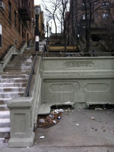
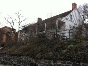
Manhattan Island: Top left is one of many “step-streets” (staircases) that climb the steep route from Broadway up to the neighborhoods and parks to the west. This one is at 215th Street and Broadway. Top right, the Dyckman Farmhouse, one of the few houses from the eighteenth century remaining in Manhattan. The house, built in 1784, is located at 204th and Broadway. The original house was located further north near 210th Street but was burned by the British during the Revolutionary War. Bottom left is the view south on Broadway towards Fort Tryon Park, another elevated area. The Cloisters can be seen on the hilltop. Bottom Right is a view down 178th Street west towards the George Washington Bridge.
There are no milestones to be found along the route of the old Post Road, or Boston Road, in Manhattan. Well, there is supposed to be one in the wall at Isham Park near 212th Street, but I did not find it, and the pictures I have seen of it indicate it is very worn and illegible, and probably of a later date anyway. It is not likely to be accurately placed either. The last remaining stone, the nine mile stone, was reputed to have been “last seen in a garden at 473 West 152nd Street some time before 1960.” (4) The ones that did exist, many of which reputedly dated from 1769, were moved in 1813 to accommodate the change in City Hall, which moved north to Foley Square, where it remains today. (5) Thus on the 1836 map of New York shown above, the 13 milestone is shown near 225th Street, and the 12 milestone is shown near the Dyckman house; both are almost a mile off the original milestones shown in Colles’s map of 1792.
The absence of milestones in Manhattan is more than compensated for by the presence of a couple of architectural reminders of the antiquity of the road. The first is an old house on the west side of Broadway at 204th Street, the Dyckman farmhouse from 1784, perched on a small rise above the main road. An even older building sits atop the hill ahead of me. This is the home of the Cloisters, which houses a part of the Metropolitan Museum’s medieval art collection. The building is a “mashup” of a number of different medieval ecclesiastical buildings brought over brick by brick from Europe in the 1930s and reassembled as one large building meant to resemble an Abbey. Thus the building’s components are actually quite ancient but, as they were not originally a part of the Post Road, I can’t claim them for the road. Still, the museum is fantastic, the building looks great from down below on Broadway, and as I make a sweeping turn on Broadway, I crane my neck to get one last glimpse before heading south down the island.
As I make my way down Broadway, with the very steep Fort Tryon Park to my right and another large hill on my left (originally the site of Fort George, visible on Jenkin’s map above), I get a real sense of the dramatic landscape of Upper Manhattan. At about 193rd Street Broadway itself begins a long steady climb uphill, culminating in a plateau about 200 feet above sea level around the George Washington Bridge at 178th Street. The neighborhood to this point has been pretty gentrified, with bars, cafes, and brick oven pizzerias lining Broadway and the lovely parks separating pockets of well-appointed apartment buildings. The upper reaches of the hills to my right are plainly well-to-do, but the stretch of Broadway beginning at about 192nd Street is a heavily Hispanic working class area and continues to be so for the next forty blocks or so until I reach Harlem. This is the heart of the Dominican community in New York. It also has a rich connection to baseball in New York, as the neighborhood, called Washington Heights, was the site of the famous Polo Grounds at 155th Street and Eighth Avenue. This park was home to the New York Giants until 1957, when they abandoned New York for the riches of San Francisco, where they failed until this past season to win a World Series title to go with the five they collected in New York. The Yankees too played in Washington Heights in their earliest days, from 1903-1912 at Hilltop Park, when the team was known as the New York Highlanders, on account of the stadium being at one of the highest points in the city, on Broadway between 165th and 168th Street, now the site of the Columbia Presbyterian Medical Center. They also played at the Polo Grounds from 1913 until 1922, before moving into the “House that Ruth Built,” Yankee Stadium. Even the Mets, Jets, and New York Football Giants graced the Polo Grounds for brief periods.
As Dominicans are renowned for producing great baseball players, it should come as no surprise to discover that two of the biggest stars of the past decade have roots in the Dominican community of Washington Heights. Alex Rodriguez, a star of the New York Yankees, was born in the neighborhood but moved to the Dominican Republic at the age of 4 and subsequently to Miami, while Manny Ramirez was born in the Dominican Republic but attended George Washington High School here in the neighborhood, where he was New York City Public School Player of the Year in 1991, before going on to a hugely successful career with the Cleveland Indians, Boston Red Sox, and other teams. (I love Manny despite the fact that he is certifiable.) Other notable alumni from George Washington High School include another famous baseball player, Rod Carew, as well as Alan Greenspan, Maria Callas, and Harry Belafonte (the ‘nice Italian boy’ of Lenny Bruce’s Governor Long).
*****
By 190th Street it is apparent that even though the road is climbing, the very high hills on either side of the road make it obvious that this is the path that was the easiest to pursue through the area to reach the other side of the island. At 179th Street I cross under the entrance ramp to the George Washington Bridge, and wave Interstate 95 and US 1 goodbye. I still have over eleven miles to go to the end of the walk, which indicates just how big New York is. At the beginning of the walk, mile eleven brought me from downtown Boston to Dedham center, and I passed through a good deal of lightly populated territory to get there. Here in Manhattan, towering apartment buildings line the road, and I have already walked almost eight miles in the city. New York is big, and walking the length of Manhattan gives me a great sense of just how big. The county of New York, which comprises Manhattan and the aforementioned Marble Hill neighborhood, contains about 1.6 million people in its famous 22 square miles. With over 70,000 people per square mile, it is easily the most densely populated place in the United States. Amazingly, the island contained over 2.7 million residents in the 1920s, when it truly was the most densely populated place on earth! The stretch of Broadway south of the bridge to 155th Street is almost 90% Hispanic according to census data, and the neighborhood is the home of over 100,000 Latinos, as the signs in Spanish along the bustling commercial Broadway testify.
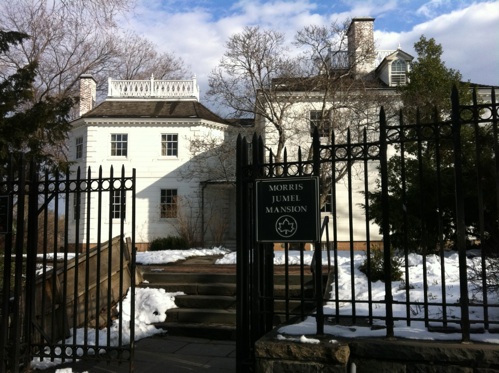
At about 172nd Street the road starts to head downhill. At 170th and Broadway Colles’s map shows the eleven mile mark, a little south of Fort Washington, the source of the name of the neighborhood. Here I leave Broadway, which follows the famous grid pattern in a straight line south on a line with what would be 11th Avenue, and join St. Nicholas Avenue, which weaves through Harlem, hugging the base of the hills that continue to run along the west side of the road. I pass through the complex of buildings associated with Columbia University Medical School and make my way onto St. Nicholas Avenue heading southeast. Around 161st Street is a historic neighborhood comprising a couple of blocks of lovely apartment buildings. The real treasure in the neighborhood lies just beyond these buildings on Jumel Terrace. Fronting the street and overlooking the Harlem River from its lofty perch sits the Morris-Jumel Mansion, the oldest house on the island of Manhattan, built in 1765 by Roger Morris, who had married a daughter of Frederick Philipse (the grandson of the King’s bridge builder). As Loyalists, the Morris and Philipse families left New York, and the property eventually fell into the hands of Stephen and Eliza Jumel. After Stephen’s death, his widow remarried Aaron Burr in 1833. Burr, who will reappear in this story in the next entry as well for even more nefarious reasons, was 77 years old at the time of the wedding, and in need of cash. His marriage to the wealthy widow lasted only a few months until she realized her income was rapidly dwindling, and she separated from the speculative Burr. He died two years later, and Eliza Jumel remained in the house alone until 1865. The building is prominently shown on Colles’s 1792 map, about halfway between mile 10 and 11 (sheet 1, strip 3).
My attempt at taking a photograph of the Morris Jumel mansion is surprisingly hazardous. As I step across the street to get a wide view of the house and raise my phone/camera to snap a photo, I notice two men across the street in front of the building waving frantically and gesturing at me. I quickly survey the situation and realize what has happened: the two men are standing near a car with dark windows, and they are clearly selling material not available at CVS. Instead of running for my life I decide to cross over and explain that I merely want to take a picture of the house and did not intend for them to unwittingly become a part of the tableau. This seems to placate them, and they helpfully suggest an angle at which I might be able to take a picture without incorporating their vehicle and persons in the photograph. I take my picture and decide to leave before they change their mind.
I head downhill through the neighborhood of handsome apartment buildings and row houses for a block or two until I reach a major cross street, 155th Street. This is roughly the site of the mile 10 marker on Christopher Colles’s map. It also marks the northern limit of Harlem. The hills are beginning to be behind me as the landscape starts to level out, and the ethnic makeup of the neighborhood also begins to change. A cafe beckons nearby, so I head in for a break before I resume my journey down Manhattan. Next stop, Harlem.
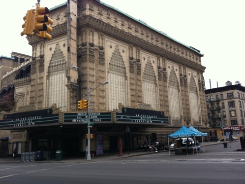
Historic buildings in Washington Heights, New York. Top, at the northeast corner of 175th and Broadway, is the amazing facade of the United Palace Theatre. Originally a movie palace built by E.M. Loew in 1930, the building was saved from abandonment by the Reverend Ike, a charismatic preacher and founder of the United Church, who restored the theater to its former glory. Today it also serves as a music hall and many well known acts have performed here in the recent past, including Bob Dylan, Sonic Youth, and The Berlin Philharmonic Orchestra. The bottom photograph is of the Morris-Jumel Mansion from a ‘safer’ perspective. This is the oldest surviving residence in Manhattan. At right (out of the picture) are some friends I made in New York.
Wednesday, April 6, 2011
Walking the Post Road
View of the Harlem River Ship Canal, which was cut through upper Manhattan in 1895, separated Marble Hill from Manhattan Island. After Spuyten Duyvil Creek was filled in two decades later, Marble Hill became part of the mainland, but remains part of New York County.
“King’s Bridge is built over a narrow river which communicates with the Hudson on the west and Long Island Sound on the east. The bridge is small, very narrow, and badly built. It is worthy of no kind of notice, except that it forms the pass from the main, on to York Island.”
Reverend Manasseh Cutler, Diary, July 5, 1786.
Notes
-
1. Sarah Knight, Diary, 70, Thursday, December 21, 1704.
-
2. Indeed, every traveler’s diary I have consulted mentions King’s Bridge: in addition to Knight, Cutler (who added that Spuyten Duyvil Creek was turbulent and that “the tide runs rapidly under the bridge, alternately both ways, as the tide ebbs and flows”),and Washington, James Birket spoke of Stephenson’s tavern, where “we had a Bass fish taken out of the river by the door before our eyes & some very good oysters &c. This is one of the best built houses for a tavern I have yet seen in America being all built of good stone and the Apartments large and lofty and a Nobel Prospect down towards the Sound; Here we cross the River upon a tall bridge made of wood the Inn and this bridge belong to the same person.” (October 12, 1750) He also noted that the river is “no(t) at all Navigable As there’s abundance of rocks between this bridge and North (Hudson) River.” Alexander Hamilton stopped at Doughty’s “who keeps a house at Kingsbridge, a fat man much troubled with rheumatism and of a hasty, passionate temper.” Hamilton too “supped upon roasted oysters, while my landlord roasted ears of corn att another table. He kept the whole house in a stirr to serve him and yet could not be pleased.” (August 30, 1744) Hamilton woke the next morning to cross the bridge and witnessed “about 10 Indians fishing for oysters in the gutt before the door (of the tavern). The wretches waded about stark naked and threw the oysters, as they picked them up with their hands, into baskets that hung upon their left shoulder. They are a lazy, indolent generation and would rather starve than work att any time, but being unacquainted with our luxury, nature in them has few demands, which are easily satisfied.” Apparently wandering about in the turbulent water harvesting oysters does not count as work. I notice Hamilton did not mention collecting his own oysters for dinner.
Over the years different innkeepers ran the two separate taverns serving the area (one on either side of the bridge). In 1697, Clapp mentioned the Kings-bridge, 16 miles away from Manhattan, but does not mention a tavern by name. The sixteen mile distance (or even eighteen miles sometimes) was a common feature of all descriptions of the route from Clapp’s time to about 1755, when the distance began to be recorded as fifteen miles. I cannot see how the route could have been longer without meandering in an aimless direction for a mile or two so I chalk the discrepancy up to an error that was blithely reproduced for a half century. Ames’s Almanac of 1759 lists a “Dickerman” Tavern at Kingsbridge, then Myers 11 miles further on, and New York 4 miles beyond that. Low’s 1767 Almanac lists “Deyckman’s” tavern at the “Kingsbridge or Prince of Wales Bridge,” again 15 miles from New York, and by 1790 Sharp has replaced Dyckman as the tavern keeper in Low’s Almanac at Kingsbridge.
Colles’s map of 1792 shows Hyatt’s tavern at the 14 mile mark on the Manhattan side of Kingsbridge while Halsey’s tavern sits on the opposite side. A littler further down Manhattan, at mile 13, Colles shows a Myer’s tavern along the road. More taverns are shown further along, but I will discuss them as I pass the areas in which they were located.
-
3.Washington, Diary, 19, and 52.
-
4.Holbrook, Story of the Post Road, 243.
-
5.George W. Nash, M.D., and Hopper Striker Mott, “The Milestones and the Old Post Road,” Reprinted from the Historical Guide to the City of New York, revised 1915 (City History Club of New York, 1909), 373.
Distance Walked in the Entry: 4.07 miles
Total Distance Walked in New York State: 24.5 miles
Total Distance Walked for this Project (from Boston): 338.1 miles
Distance Remaining to New York (Bowling Green): 10 miles